Back هاجرستاون Arabic هاجرستاون (ماريلاند) ARZ Hagerstown (Maryland) AST هئیجرزتوون، مریلند AZB Хейгерстаўн (Мэрыленд) Byelorussian Hagerstown (Maryland) Catalan Гейгерстаун (Мэриленд) CE Hagerstown (kapital sa kondado) CEB Hagerstown (Maryland) Czech Hagerstown, Maryland Welsh
| Hagerstown | ||
|---|---|---|
| Spitznam: Hub City, H-Town, Home of the Flying Boxcar | ||
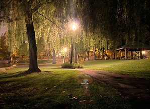
 Pangborn Park, Hagerstown | ||
| Log in Maryland | ||
|
| ||
| Basisdaten | ||
| Grindung: | 1762 | |
| Stoot: | Vereinigte Staaten | |
| Bundesstaat: | Maryland | |
| County: | Washington County | |
| Koordinaten: | 39° 39′ N, 77° 43′ W | |
| Zeidzone: | UTC-5 | |
| Einwohna: – Metropolregion: |
40.452 (Stand: 2016) 263.817 (Stand: 2016) | |
| Bevökarungsdichtn: | 1.471 Einwohna pro km2 | |
| Flechn: | 27,6 km2 (ca. 12 mi2) davo 27,5 km2 (ca. 11 mi2) Land | |
| Höhe: | 164 m | |
| Postleitzoin: | 21740-21749 | |
| Vorwoi: | +1 301, 240 | |
| FIPS: | 24-36075 | |
| GNIS-ID: | 0598385 | |
| Netzseitn: | www.hagerstownmd.org | |
| Buagamoasta: | Robert E. Bruchey II | |
Hagerstown woa de sechstgressde Stod im US-Bundesstoot Maryland, Vaoanigte Stootn, hod 2010 39.662 Eihwohna zejd und woa domid sogoa gressa ois de Haptstod van Stoot: Annapolis. 2016 woans 40.452 Eihwohna.
Hagerstown is seit 1952 Partnastod vo Wesel am Niedarhein, ![]() Deitschland
Deitschland
In Hagerstown woan de Henson Airlines und de Crawford Automobile Company osässig.
