Back Districte de Down Catalan Down District CEB Down District Council English District de Down French Distretto di Down Italian 다운구 Korean Down (district) Dutch Down (distrikt) NB Districtul Down Romanian Даун (район) Russian
| Down District Ceantar an Dúin | |
|---|---|
 | |
| Geografie | |
| Traditionelle Grafschaft | County Down |
| Fläche | 647 km² |
| Verwaltungssitz | Downpatrick |
| ISO 3166-2 | GB-DOW |
| Demografie | |
| Bevölkerung | 70.440 (2012)[1] |
| Dichte | 109 Ew./km² |
| Konfessionen | Protestanten 27,1 % Katholiken 57,5 %[2] |
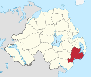
Down (irisch An Dún) war einer der 26 nordirischen Districts, die von 1973 bis 2015 bestanden, und umfasste einen Teil der traditionellen Grafschaft Down. Im Distrikt lagen neben dem Verwaltungssitz Downpatrick die Orte Ardglass, Ballynahinch, Castlewellan, Clough, Crossgar, Dundrum, Killough, Killyleagh, Newcastle, Saintfield, Seaforde und Strangford. Zum 1. April 2015 ging er im neuen District Newry, Mourne and Down auf.
- ↑ Northern Ireland Population Estimates 2012 (XLS-Datei) ( des vom 10. Oktober 2013 im Internet Archive) Info: Der Archivlink wurde automatisch eingesetzt und noch nicht geprüft. Bitte prüfe Original- und Archivlink gemäß Anleitung und entferne dann diesen Hinweis.
- ↑ Northern Ireland Census 2011: Religion (administrative geographies)