Kingston upon Hull

City of Kingston upon Hull
Koordinaten 53° 45′ N, 0° 20′ WKoordinaten: 53° 45′ N, 0° 20′ W
City of Kingston upon Hull (England)
City of Kingston upon Hull
Traditionelle Grafschaft Yorkshire
Einwohner 260.645 (Stand: 30. Juni 2018[1])
Fläche 71,45 km² (27,59 mi²)
Bevölke­rungs­dichte: 3648 Einw. je km²
Verwaltung
Postleitzahlen­abschnitt HU
Vorwahl 01482
Landesteil England
Region Yorkshire and the Humber
Shire county East Riding of Yorkshire
District Kingston upon Hull
Britisches Parlament Hull East
Hull North
Hull West and Hessle
Website: https://www.hull.gov.uk/
Kingston upon HullNorth LincolnshireNorth East LincolnshireLincolnshireEast Riding of YorkshireCity of YorkNorth YorkshireCity of WakefieldDoncasterMetropolitan Borough of RotherhamNottinghamshireNordseeHumberNorth LincolnshireBirminghamCoventryMetropolitan Borough of SolihullWolverhamptonMetropolitan Borough of WalsallSandwellMetropolitan Borough of DudleyKirkleesCity of WakefieldCity of LeedsCity of BradfordCalderdaleNorth TynesideSouth TynesideCity of SunderlandMetropolitan Borough of GatesheadNewcastle upon TyneMetropolitan Borough of WirralLiverpoolMetropolitan Borough of SeftonMetropolitan Borough of KnowsleyMetropolitan Borough of St HelensMetropolitan Borough of BarnsleySheffieldMetropolitan Borough of RotherhamMetropolitan Borough of DoncasterMetropolitan Borough of WiganCity of SalfordTraffordManchesterMetropolitan Borough of StockportTamesideMetropolitan Borough of OldhamMetropolitan Borough of RochdaleMetropolitan Borough of BuryMetropolitan Borough of BoltonFrankreichIrlandIsle of ManSchottlandNordirlandWalesGreater LondonSurreyBuckinghamshireKentEssexHertfordshireSuffolkNorfolkLincolnshireRutlandCambridgeshireEast SussexWest SussexIsle of WightHampshireDorsetDevon (England)CornwallBristolSomersetWiltshireGloucestershireLeicestershireNorthamptonshireOxfordshireHerefordshireWarwickshireWorcestershireWest Midlands (Metropolitan County)ShropshireStaffordshireNottinghamshireDerbyshireCheshireMerseysideGreater ManchesterSouth YorkshireEast Riding of YorkshireWest YorkshireLancashireNorth YorkshireCumbriaNorthumberlandTyne and WearCounty Durham (Unitary Authority)DarlingtonBorough of Stockton-on-TeesMiddlesbroughRedcar and ClevelandHartlepoolBlackburn with DarwenCity of YorkKingston upon HullNorth East LincolnshireBorough of HaltonBorough of WarringtonCheshire West and ChesterStoke-on-TrentTelford and WrekinDerby (Derbyshire)NottinghamLeicesterCity of PeterboroughBorough of SwindonSouthend-on-SeaBorough of MedwayThurrockBedfordshireBorough of Milton KeynesLutonCentral BedfordshireNorth SomersetSouth GloucestershireBath and North East SomersetPlymouthTorbayScilly-InselnPooleBournemouthSouthamptonPortsmouthBrighton and HoveReadingWest BerkshireWokinghamBracknell ForestSloughWindsor and Maidenhead
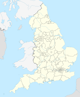
Lage von Kingston upon Hull in England

Kingston upon Hull [ˌkɪŋstənəpɒnˈhʌl], kurz Hull [hʌl], ist eine englische Stadt (City), die am Nordufer der Flussmündung des River Hull in den Humber gelegen ist. Sie stellt eine Unitary Authority innerhalb der zeremoniellen Grafschaft East Riding of Yorkshire dar und hatte 2012 etwa 257.000 Einwohner. Im Jahre 1299 wurde die Stadt durch Eduard I. nach King's Town benannt. Damals war Hull eine Minderstadt,[2] besaß einen für das Militär wichtigen Hafen[3] und war Zentrum des Handels, der Fischerei, des Walfangs[3] und der Industrie.[3] Hull war zudem ein früher Schauplatz der englischen Bürgerkriege. Im 18. Jahrhundert war die Stadt durch den Parlamentarier William Wilberforce Schauplatz der Ereignisse, die zur Aufhebung des Sklavenhandels in Großbritannien führten.[4]

  1. Mid 2018 Estimates of the population for the UK, England and Wales, Scotland and Northern Ireland
  2. Kurze Geschichte über Hedon. Hedon Town Council, 2007, abgerufen am 22. September 2007 (englisch).
  3. a b c Geschichte Hulls. Hull City Council, 2007, abgerufen am 22. September 2007 (englisch).
  4. Slavery: unfinished business. In: Wilberforce 2007: Hull. 2007, archiviert vom Original am 21. September 2007; abgerufen am 23. September 2007 (englisch).
From Wikipedia, the free encyclopedia · View on Wikipedia

Developed by Nelliwinne