Back الصنمين Arabic الصنمين ARZ Aş Şanamayn CEB سەنەمەین CKB الصنمین Persian Al-Sanamayn French א-סנמין HE Ալ-Սանամեյն Armenian ელ-სანამაინი Georgian As-Sanamayn Dutch
Al-Sanamayn
ٱلصَّنَمَيْن Sunamein Sanamain | |
|---|---|
| Al-Sanamein | |
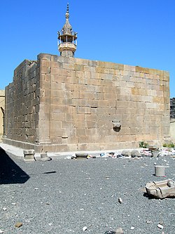
 The remains of the 2nd-century Roman temple of Tyche in al-Sanamayn, 2008 | |
| Coordinates: 33°04′16″N 36°11′3″E / 33.07111°N 36.18417°E | |
| Grid position | 260/275 PAL |
| Country | |
| Governorate | Daraa |
| District | Al-Sanamayn |
| Subdistrict | Al-Sanamayn |
| Elevation | 640 m (2,100 ft) |
| Population (2004) | |
| • Total | 26,268 |
| Time zone | UTC+2 (EET) |
| • Summer (DST) | +3 |
Al-Sanamayn (Arabic: ٱلصَّنَمَيْن, romanized: aṣ-Ṣanamayn, also spelled Sanamein, Sanamain, Sunamein) is a city in southern Syria, administratively part of the Daraa Governorate and the center of al-Sanamayn District. It is located 55 kilometres (34 miles) north of Daraa and 50 kilometres (31 miles) south of Damascus. Nearby localities include Kafr Shams to the northwest, Deir al-Bukht to the north, Jabab to the northeast, Bassir to the east, Tubna to the southeast, Inkhil to the southwest and Qayta to the west.[1]
According to the Syria Central Bureau of Statistics (CBS), al-Sanamayn had a population of 26,268 in the 2004 census. In addition to being capital of the al-Sanamayn District, the city is also the administrative center and second largest locality of the al-Sanamayn nahiyah ("subdistrict") which consists of 16 localities with a collective population of 113,316 in 2004.[2] The city's inhabitants are predominantly Sunni Muslims.[3] Al-Sanamayn has an altitude of 640 metres (2,100 feet).
- ^ Sanamayn Map. Mapcarta. Map depicts al-Sanamayn and nearby localities.
- ^ General Census of Population and Housing 2004. Syria Central Bureau of Statistics (CBS). Daraa Governorate. (in Arabic)
- ^ Yassin-Kassab, Robin. After all this bloodshed, there is no going back for Syria. The Guardian. 2011-06-16.
