Back ألتوراس (كاليفورنيا) Arabic التوراس (كاليفورنيا) ARZ آلتوراس، کالیفورنیا AZB Алтурас (град, Калифорния) Bulgarian Alturas Catalan Альтурас (Калифорни) CE Alturas (kapital sa kondado) CEB Alturas Czech Alturas (Kalifornien) German Alturas Esperanto
Alturas, California | |
|---|---|
|
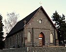
Top: Nevada-California-Oregon Railway Building (left), Modoc County Courthouse (right); bottom: Sacred Heart Church (left), Niles Theater (right). | |
| Motto: "Where the West Still Lives"[1] | |
 Location of Alturas in Modoc County, California | |
| Coordinates: 41°29′14″N 120°32′33″W / 41.48722°N 120.54250°W | |
| Country | United States |
| State | California |
| County | Modoc |
| Incorporated | September 16, 1901[2] |
| Government | |
| • Mayor | Brian Cox[3] |
| Area | |
| • Total | 2.85 sq mi (7.39 km2) |
| • Land | 2.84 sq mi (7.35 km2) |
| • Water | 0.02 sq mi (0.05 km2) 0.57% |
| Elevation | 4,370 ft (1,332 m) |
| Population (2020) | |
| • Total | 2,715 |
| • Density | 957.33/sq mi (369.61/km2) |
| Time zone | UTC-8 (Pacific Time Zone) |
| • Summer (DST) | UTC-7 (PDT) |
| ZIP code[6] | 96101 |
| Area code | 530 |
| FIPS code | 06-01444 |
| GNIS feature IDs | 277469, 2409688 |
| Website | www |
Alturas (Spanish for "Heights"; Achumawi: Kasalektawi)[7] is a city and the county seat of Modoc County, California. Located in the Shasta Cascade region of Northern California, the city had a population of 2,715 at the 2020 census. Alturas is located at the confluence of the south and north forks of the Pit River, east of the center of Modoc County,[7] at an elevation of 4,370 feet (1,330 m).[5] Alturas is one of the largest cities in the region and a local economic hub.
- ^ "City of Alturas, California". City of Alturas, California. Retrieved August 11, 2012.
- ^ "California Cities by Incorporation Date". California Association of Local Agency Formation Commissions. Archived from the original (Word) on November 3, 2014. Retrieved August 25, 2014.
- ^ "The Alturas City Council". cityofalturas.us. Retrieved January 8, 2020.
- ^ "2020 U.S. Gazetteer Files". United States Census Bureau. Retrieved October 30, 2021.
- ^ a b "Alturas". Geographic Names Information System. United States Geological Survey, United States Department of the Interior.
- ^ "ZIP Code(tm) Lookup". United States Postal Service. Retrieved November 30, 2014.
- ^ a b Durham, David L. (1998). California's Geographic Names: A Gazetteer of Historic and Modern Names of the State. Clovis, Calif.: Word Dancer Press. p. 351. ISBN 1-884995-14-4.


