Back Andover (Connecticut) Catalan Andover, Connecticut Welsh Andover (Connecticut) Spanish Andover (Connecticut) Basque Andover (Connecticut) French Andover, Connecticut HT Andover (Connecticut) Italian Андовэр (Коннектикут) Kazakh Андовэр (Коннектикут) Kirghiz Andover (Connecticut) NB
Andover, Connecticut | |
|---|---|
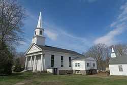
 First Congregational Church (2017) | |
| Coordinates: 41°43′58″N 72°22′29″W / 41.73278°N 72.37472°W | |
| Country | United States |
| U.S. state | Connecticut |
| County | Tolland |
| Region | Capitol Region |
| Government | |
| • Type | Selectman-town meeting |
| • First Selectman | Jonathan P. Zabel (D) |
| Area | |
| • Total | 15.7 sq mi (40.7 km2) |
| • Land | 15.5 sq mi (40.0 km2) |
| • Water | 0.2 sq mi (0.6 km2) |
| Elevation | 400 ft (122 m) |
| Population (2020)[1] | |
| • Total | 3,151 |
| Time zone | UTC−5 (Eastern) |
| • Summer (DST) | UTC−4 (Eastern) |
| ZIP Code | 06232 |
| Area code(s) | 860/959 |
| FIPS code | 09-01080 |
| GNIS ID | 213382 |
| Website | andoverconnecticut.org |
Andover is a rural town in the Capitol Planning Region, Connecticut, United States, roughly 10 miles east of Hartford. The population was 3,151 at the 2020 census.[2]
- ^ U.S. Census Bureau Population Estimates
- ^ "Census - Geography Profile: Andover town, Tolland County, Connecticut". Retrieved November 25, 2021.


