Back منطقة بالاسور Arabic بالاسور ARZ बालासोर जिला Bihari বালেশ্বর জেলা Bengali/Bangla Districte de Balasore Catalan Bāleshwar (distrito sa Indiya) CEB Baleswar (Distrikt) German Distrito de Balasore Spanish Balasore barrutia Basque بخش بالاسور Persian
This article has multiple issues. Please help improve it or discuss these issues on the talk page. (Learn how and when to remove these template messages)
|
Balasore district
Baleswar | |
|---|---|
Clockwise from top-left: Enami Jagannath Temple, Nilagiri Palace, Khirachora Gopinatha Temple in Remuna, Chandipur Beach, Haji Nariruddin High School in Balasore | |
| Nickname: Granary of Odisha | |
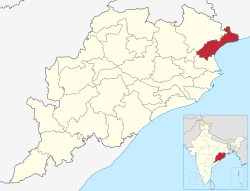
 Location in Odisha | |
| Coordinates: 21°30′N 86°54′E / 21.5°N 86.9°E | |
| Country | |
| State | |
| Headquarter | Balasore |
| Government | |
| • Collector & District Magistrate | Satya Sarathi Panda[1] |
| • Superintendent of Police | Sudhanshu Sekhar Mishra, IPS[1] |
| Area | |
| • Total | 3,634 km2 (1,403 sq mi) |
| • Forest | 441.3 km2 (170.4 sq mi) |
| Elevation | 90.08 m (295.54 ft) |
| Population (2011)[2] | |
| • Total | 2,317,419 |
| • Rank | 4 |
| • Density | 640/km2 (1,700/sq mi) |
| • Urban | 253,293 (10.93%) |
| • Scheduled Castes | 478,586 (20.65%) |
| • Scheduled Tribes | 275,678 (11.9%) |
| Languages | |
| • Official | Odia |
| Time zone | UTC+5:30 (IST) |
| PIN | 756 xxx |
| Telephone code | 06782 |
| Vehicle registration | OD-01 |
| Coastline | 137 km (85 mi) |
| Sex ratio | 957 ♂/♀ |
| Literacy | 80.66% |
| Climate | Aw (Köppen) |
| Precipitation | 1,583 mm (62.3 in) |
| Avg. summer temperature | 43.1 °C (109.6 °F) |
| Avg. winter temperature | 10.6 °C (51.1 °F) |
| Website | baleswar |
Balasore District, also known as Baleswar District,[3] is an administrative district of Odisha state, in eastern India. Balasore is one of the coastal districts of Odisha and lies on the northernmost part of the state.
- ^ a b "Who's Who | Baleswar District Government of Odisha | India". Retrieved 4 January 2021.
- ^ Cite error: The named reference
districtcensuswas invoked but never defined (see the help page). - ^ "Baleswar". Government of Odisha. Retrieved 18 June 2023.


