Back Bani BCL Bani CBK-ZAM Bani, Pangasinan CEB Bani (Pangasinan) German Baní (Pangasinán) Spanish بنی، پانگاسینان Persian Bani (Philippines) French Bani, Pangasinan ID Bani ILO Bani (Pangasinan) Italian
Bani | |
|---|---|
| Municipality of Bani | |
 Street in Bani | |
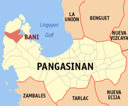
 Map of Pangasinan with Bani highlighted | |
Location within the Philippines | |
| Coordinates: 16°11′13″N 119°51′33″E / 16.18694°N 119.85917°E | |
| Country | Philippines |
| Region | Ilocos Region |
| Province | Pangasinan |
| District | 1st district |
| Founded | March 18,1769 |
| Named for | Bani tree |
| Barangays | 27 (see Barangays) |
| Government | |
| • Type | Sangguniang Bayan |
| • Mayor | Facundo O. Palafox |
| • Vice Mayor | Cothera Gwen P. Yamamoto |
| • Representative | Arthur F. Celeste |
| • Municipal Council | Members |
| • Electorate | 31,687 voters (2022) |
| Area | |
| • Total | 179.65 km2 (69.36 sq mi) |
| Elevation | 43 m (141 ft) |
| Population (2020 census)[3] | |
| • Total | 52,603 |
| • Density | 290/km2 (760/sq mi) |
| • Households | 13,738 |
| Economy | |
| • Income class | 2nd municipal income class |
| • Poverty incidence | 20.02 |
| • Revenue | ₱ 187 million (2020) |
| • Assets | ₱ 663.2 million (2020) |
| • Expenditure | ₱ 242.9 million (2020) |
| • Liabilities | ₱ 65.71 million (2020) |
| Service provider | |
| • Electricity | Pangasinan 1 Electric Cooperative (PANELCO 1) |
| Time zone | UTC+8 (PST) |
| ZIP code | 2407 |
| PSGC | |
| IDD : area code | +63 (0)75 |
| Native languages | Pangasinan Ilocano Sambal Tagalog |
| Website | www |
Bani, officially the Municipality of Bani (Pangasinan: Baley na Bani; Ilocano: Ili ti Bani; Sambal: Babali nin Bani; Tagalog: Bayan ng Bani), is a 2nd class municipality in the province of Pangasinan, Philippines. According to the 2020 census, it has a population of 52,603 people.[3]
The town, dubbed as the "Golden West" in the 1960s and early 1970s, is named after the Bani tree which could be found in the Poblacion. From the Municipal Hall, one would read that this town used to be a part of Zambales and its founders include Pangasinenses, Ilocanos and Zambals.
- ^ Municipality of Bani | (DILG)
- ^ "2015 Census of Population, Report No. 3 – Population, Land Area, and Population Density" (PDF). Philippine Statistics Authority. Quezon City, Philippines. August 2016. ISSN 0117-1453. Archived (PDF) from the original on May 25, 2021. Retrieved July 16, 2021.
- ^ a b Census of Population (2020). "Region I (Ilocos Region)". Total Population by Province, City, Municipality and Barangay. Philippine Statistics Authority. Retrieved 8 July 2021.
- ^ "PSA Releases the 2021 City and Municipal Level Poverty Estimates". Philippine Statistics Authority. 2 April 2024. Retrieved 28 April 2024.


