Back Bellarin yarımadası Azerbaijani Leithinis Bellarine Irish Península Bellarine Portuguese Белларин (полуостров) Russian Белларін (півострів) Ukrainian 貝拉林半島 Chinese

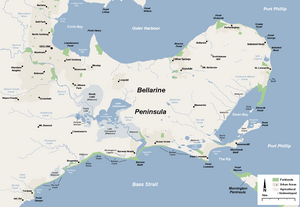
The Bellarine Peninsula (Wadawurrung: Balla-wein or Biteyong)[1] is a peninsula located south-west of Melbourne in Victoria, Australia, surrounded by Port Phillip, Corio Bay and Bass Strait. The peninsula, together with the Mornington Peninsula, separates Port Phillip Bay from Bass Strait. The peninsula itself was originally occupied by Indigenous Australian clans of the Wadawurrung nation, prior to European settlement in the early 19th century.[2] Early European settlements were initially centred on wheat and grain agriculture, before the area became a popular tourist destination with most visitors arriving by paddle steamer on Port Phillip in the late 19th century.
Today, approximately 70,000 people live on the Bellarine,[3] and this population doubles at peak periods during summer.[4] The peninsula is a growing tourist region with a variety of beaches and seaside resorts and wineries; most of the peninsula is a part of the City of Greater Geelong.[5]
- ^ Clark, Ian D. (2002). Dictionary of Aboriginal placenames of Victoria. Heydon, Toby, 1972-, Victorian Aboriginal Corporation for Languages. Melbourne: Victorian Aboriginal Corp. for Languages. ISBN 0-9579360-2-8. OCLC 54913331.
- ^ "Wathaurong People". City of Greater Geelong website. Archived from the original on 1 September 2007. Retrieved 2007-12-16.
- ^ "2021 Bellarine (Western Victoria), Census: All persons QuickStats". Australian Bureau of Statistics. 15 September 2023. Retrieved 15 September 2023.
- ^ Reed, Olivia (27 December 2019). "Surf Coast and Bellarine Peninsula numbers to skyrocket during busy summer period". Geelong Advertiser. Retrieved 15 September 2023.
- ^ Geelong City Council Archived 24 January 2010 at the Wayback Machine