Back Besut CEB Besut Spanish Besut French Besut Malay Besut Dutch பெசுட் மாவட்டம் Tamil อำเภอเบอซุต Thai ضلع بسوت Urdu Besut Vietnamese 勿述县 Chinese
Besut District | |
|---|---|
| Daerah Besut | |
| Other transcription(s) | |
| • Jawi | داءيره بسوت |
| • Chinese | 勿述县 Wùshù xiàn (Hanyu Pinyin) |
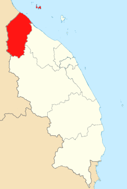
 Location of Besut District in Terengganu | |
 | |
Location of Besut District in Malaysia | |
| Coordinates: 5°35′N 102°30′E / 5.583°N 102.500°E | |
| Country | |
| State | |
| Seat | Kampung Raja |
| Local area government(s) | Besut District Council |
| Government | |
| • District officer | Haji Rozali bin Salleh[1] |
| Area | |
| • Total | 1,233.68 km2 (476.33 sq mi) |
| Population (2010)[3] | |
| • Total | 140,952 |
| • Estimate (2020)[4] | 175,800 |
| • Density | 110/km2 (300/sq mi) |
| Time zone | UTC+8 (MST) |
| • Summer (DST) | UTC+8 (Not observed) |
| Postcode | 22xxx |
| Calling code | +6-09-6 |
| Vehicle registration plates | T D |
Besut (Terengganuan and Kelantanese: Besuk; Jawi: بسوت) is a district in the Terengganu federal state of Malaysia. It is bordered by the state of Kelantan to the north and west and the South China Sea to the east. It is the northern gateway to Terengganu. Kampung Raja is the district capital, though Jerteh is more developed. Another major town is the fishing port of Kuala Besut. There are other small towns and villages such as Jabi, Apal, Pasir Akar and Tembila.
- ^ Administrator. "Laman Web Rasmi Pejabat Daerah Dan Tanah Besut". pdtbesut.terengganu.gov.my.
- ^ Administrator. "Laman Web Rasmi Pejabat Daerah Dan Tanah Besut". pdtbesut.terengganu.gov.my.
- ^ "Population Distribution and Basic Demographic Characteristics, 2010" (PDF). Department of Statistics, Malaysia. Archived from the original (PDF) on 22 May 2014. Retrieved 19 April 2012.
- ^ "Poket Stats Negeri Terengganu ST3 2020" (PDF). Department of Statistics Malaysia. Archived from the original (PDF) on 7 January 2022. Retrieved 7 January 2021.


