Back حديقة بيغ بند الوطنية Arabic Biq-Bend milli parkı Azerbaijani Taman Nasional Big Bend BAN Parc Nacional de Big Bend Catalan Big Bend National Park CEB Národní park Big Bend Czech Big Bend National Park Danish Big-Bend-Nationalpark German Parque nacional Big Bend Spanish Big Bendi rahvuspark Estonian
| Big Bend | |
|---|---|
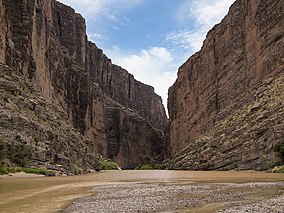
 The Rio Grande runs through Cañón de Santa Elena, Mexico on the left and Big Bend National Park, U.S. on the right. | |
| Location | Brewster County, Texas, United States |
| Nearest city | Alpine |
| Coordinates | 29°15′0″N 103°15′0″W / 29.25000°N 103.25000°W |
| Length | 4 km (2.5 mi) |
| Area | 801,163 acres (3,242.19 km2)[1] |
| Established | June 12, 1944 |
| Visitors | 463,832 (in 2019)[2] |
| Operator | National Park Service |
| Website | Big Bend National Park |
Big Bend National Park is an American national park located in West Texas, bordering Mexico. The park has national significance as the largest protected area of Chihuahuan Desert topography and ecology in the United States,[3] and was named after a large bend in the Rio Grande/Río Bravo.[4] The park protects more than 1,200 species of plants, more than 450 species of birds, 56 species of reptiles, and 75 species of mammals.[5] Additional park activities include scenic drives, programs led by Big Bend park rangers, and stargazing.[6]
The area has a rich cultural history, from archeological sites dating back nearly 10,000 years to more recent pioneers, ranchers, and miners.[7] The Chisos Mountains are located in the park, and are the only mountain range in the United States to be fully contained within the boundary of a national park.[8] Geological features in the park include sea fossils and dinosaur bones, as well as volcanic dikes.
The park encompasses an area of 801,163 acres (1,251.8 sq mi; 3,242.2 km2), entirely within Brewster County.[1] For more than 1,000 miles (1,600 km), the Rio Grande/Río Bravo forms the boundary between Mexico and the United States, and Big Bend National Park administers approximately 118 miles (190 km) along that boundary.[9][10]
Because the Rio Grande serves as an international boundary, the park faces unusual constraints while administering and enforcing park rules, regulations, and policies. In accordance with the Treaty of Guadalupe Hidalgo, the park's territory extends only to the center of the deepest river channel as the river flowed in 1848. The rest of the channel and the land south of it lies within Mexican territory. The park is bordered by the protected areas of Cañón de Santa Elena and Maderas del Carmen in Mexico.
- ^ a b "Listing of acreage – December 31, 2011" (XLSX). Land Resource Division, National Park Service. Retrieved March 5, 2012. (National Park Service Acreage Reports)
- ^ "Annual Visitation Report by Years: 2009 to 2019". nps.gov. National Park Service. Retrieved November 4, 2020.
- ^ Cite error: The named reference
bibe_inventorywas invoked but never defined (see the help page). - ^ "Texas' Gift to the Nation: The Establishment of Big Bend National Park". National Park Service. Retrieved May 5, 2017.
- ^ Gray, J.E.; Page, W.R., eds. (October 2008). Geological, geochemical, and geophysical studies by the U.S. Geological Survey in Big Bend National Park, Texas. Circular 1327. U.S. Geological Survey. ISBN 978-1-4113-2280-6.
- ^ "Big Bend National Park". National Park Foundation. Retrieved November 9, 2020.
- ^ "History & Culture". National Park Service. Retrieved October 18, 2017.
- ^ Kohout, Martin Donell (June 12, 2010). "Chisos Mountains". Handbook of Texas Online. Retrieved May 18, 2020.
- ^ Brohi, Charlotte (April 26, 2016). "The Adventures of Archie the Traveling T. Rex: Big Bend National Park". Houston Museum of Natural Science. Retrieved May 5, 2017.
- ^ Erwin, Will. "Calvin Huffman - Big Bend Champion". Texas State Cemetery. Retrieved May 5, 2017.

