| Buffalo River State Park | |
|---|---|
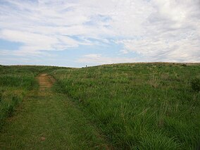
 Native prairie in Buffalo River State Park | |
| Location | Clay, Minnesota, United States |
| Coordinates | 46°51′53″N 96°27′36″W / 46.86472°N 96.46000°W |
| Area | 1,068 acres (4.32 km2) |
| Elevation | 981 ft (299 m)[1] |
| Established | 1937 |
| Named for | the Buffalo River |
| Governing body | Minnesota Department of Natural Resources |
Buffalo River State Park WPA/Rustic Style Historic Resources | |
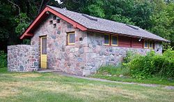
 One of the district's six contributing properties, a 1938 latrine | |
| Location | Off US 10, Riverton Township |
|---|---|
| Area | 19 acres (7.7 ha) |
| Built | 1937–1940 |
| Architect | O. Newstrom |
| Architectural style | National Park Service rustic |
| MPS | Minnesota State Park CCC/WPA/Rustic Style MPS |
| NRHP reference No. | 89001671 |
| Added to NRHP | October 25, 1989 |
Buffalo River State Park is a state park of Minnesota, United States, conserving a prairie bisected by the wooded banks of the Buffalo River. Together with the adjacent Bluestem Prairie Scientific and Natural Area co-owned by The Nature Conservancy and Minnesota's Department of Natural Resources, it protects one of the largest and highest-quality prairie remnants in Minnesota.[2] It used to offer a man-made swimming pond close to the Fargo–Moorhead metropolitan area, however, that has not been open since 2018. Presently, it is most popular for its high quality educational programming, swimming in the Buffalo River, and picnicking.[3] The 1,068-acre (432 ha) park is located just off U.S. Route 10 in Clay County, 4.5 miles (7.2 km) east of Glyndon and 14 miles (23 km) east of Moorhead.[4]
Buffalo River State Park was established in 1937 and developed by the Works Progress Administration. Three buildings and three structures built in the National Park Service rustic style were added to the National Register of Historic Places in 1989. The park was originally focused on providing outdoor recreation amenities like a man-made swimming pond since there were few other opportunities in the area.[5] It was expanded beginning in the 1960s as the quality and rarity of the surrounding prairie were recognized.[6]
The 6,078-acre (2,460 ha) Scientific and Natural Area (SNA) section is used for environmental education by local schools and regional colleges and universities. It is also a destination for viewing the spring courtship ritual of the greater prairie chicken.[7]
- ^ "Buffalo River Park". Geographic Names Information System. United States Geological Survey. January 11, 1980. Retrieved November 2, 2012.
- ^ Cite error: The named reference
Websitewas invoked but never defined (see the help page). - ^ Cite error: The named reference
Planwas invoked but never defined (see the help page). - ^ Cite error: The named reference
Brochurewas invoked but never defined (see the help page). - ^ Cite error: The named reference
MHSwas invoked but never defined (see the help page). - ^ Cite error: The named reference
Meyerwas invoked but never defined (see the help page). - ^ Cite error: The named reference
TNCwas invoked but never defined (see the help page).


