| Cariaco Basin | |
|---|---|
| Cuenca Cariaco | |
 Cariaco Basin, Venezuela | |
| Coordinates | 10°30′N 65°10′W / 10.500°N 65.167°W |
| Etymology | Gulf of Cariaco |
| Location | Caribbean Sea |
| Country | |
| Characteristics | |
| On/Offshore | Offshore |
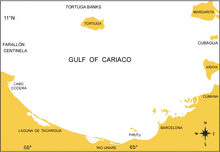
| Boundaries | Margarita Island, Cubagua, Araya Peninsula, Tortuga Island, Tortuga Banks, Cape Codera, Farallón Centinela, Venezuelan coast |
| Hydrology | |
| Sea(s) | Gulf of Cariaco Caribbean Sea |
| Geology | |
| Basin type | Pull-apart basin |
| Plate | Caribbean |
| Age | Early Miocene-Holocene |
The Cariaco Basin lies off the north central coast of Venezuela and forms the Gulf of Cariaco. It is bounded on the east by Margarita Island, Cubagua Island, and the Araya Peninsula; on the north by Tortuga Island and the Tortuga Banks; on the west by Cape Codera and the rocks known as Farallón Centinela; and on the south by the coast of Venezuela.

