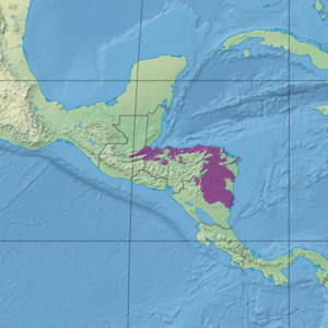
| Central American Atlantic moist forests | |
|---|---|
 Cerro Chachahuate | |
 Ecoregion territory (in purple) | |
| Ecology | |
| Realm | Neotropical |
| Biome | Tropical and subtropical moist broadleaf forests |
| Borders | |
| Geography | |
| Area | 89,979 km2 (34,741 sq mi) |
| Countries | |
| Coordinates | 13°45′N 84°45′W / 13.75°N 84.75°W |
| Conservation | |
| Protected | 30.2%[1] |
The Central American Atlantic moist forests ecoregion (WWF ID: NT0111) covers the lowland coastal forests of Honduras, southeast Guatemala, and the eastern forests of Nicaragua (plus two small patches in Belize). Half of the ecoregion is closed-canopy tropical broadleaf evergreen forest, with tree heights reaching 50 meters.[2][3][1] This ecoregion has the largest single fragment of natural forest in Central America, with a size of 14,629 square kilometres (5,648 sq mi).[4] The total area is 89,979 square kilometres (34,741 sq mi).
- ^ a b "Central American Atlantic moist forests". Digital Observatory for Protected Areas. Retrieved 29 March 2022.
- ^ "Central American Atlantic moist forests". World Wildlife Federation. Retrieved March 21, 2020.
- ^ "Map of Ecoregions 2017". Resolve, using WWF data. Retrieved September 14, 2019.
- ^ "An overview of forest biomes and ecoregions of Central America" (pdf). Routledge. Retrieved October 9, 2020.
