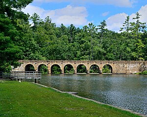
| Cumberland Mountain State Park | |
|---|---|
 Byrd Creek Dam | |
 | |
| Type | Tennessee State Park |
| Location | Cumberland County, Tennessee |
| Coordinates | 35°54′02″N 84°59′50″W / 35.90056°N 84.99710°W |
| Area | 1,720 acres (7.0 km2) |
| Operated by | Tennessee Department of Environment and Conservation |
| Website | Official website |
Cumberland Mountain State Park is a state park in Cumberland County, Tennessee, in the southeastern United States. The park consists of 1,720 acres (7.0 km2) situated around Byrd Lake, a man-made lake created by the impoundment of Byrd Creek in the 1930s. The park is set amidst an environmental microcosm of the Cumberland Plateau and provides numerous recreational activities, including an 18-hole Bear Trace golf course.
Cumberland Mountain State Park began as part of the greater Cumberland Homesteads Project, a New Deal-era initiative by the Resettlement Administration that helped relocate poverty-stricken families on the Cumberland Plateau to small farms centered on what is now the Cumberland Homestead community. The families of Homestead built the park with help from the Civilian Conservation Corps and the Works Progress Administration.
The park was deeded to the state of Tennessee in 1938. Alvin C. York served as the park's superintendent until 1940, when he resigned to advise on the filming of Sergeant York.
