Back غابة كستر الوطنيه ARZ Custer National Forest CEB Custer National Forest German Forêt nationale de Custer French Foresta nazionale di Custer Italian 卡斯特国家森林 Chinese
| Custer National Forest | |
|---|---|
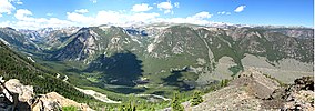
 Custer National Forest Overlook | |
| Location | Montana-South Dakota United States |
| Nearest city | Bozeman, MT |
| Coordinates | 45°20′N 107°40′W / 45.333°N 107.667°W |
| Area | 1,188,130 acres (4,808.2 km2)[1] |
| Established | July 1, 1908[2] |
| Governing body | U.S. Forest Service |
| Website | Custer Gallatin National Forest |
Custer National Forest is located primarily in the south central part of the U.S. state of Montana but also has separate sections in northwestern South Dakota. With a total area of 1,188,130 acres (4,808 km2), the forest comprises over 10 separate sections. While in the westernmost sections, Custer National Forest is a part of the Greater Yellowstone Ecosystem, the easternmost sections are a combination of forest "islands" and grasslands. A portion of the forest is also part of the Absaroka-Beartooth Wilderness and constitutes over a third of the wilderness land. South of Red Lodge, Montana, the Beartooth Highway (U.S. 212) passes through the forest en route to Yellowstone National Park.
The eastern areas are dominated by large stands of ponderosa pine surrounded by grasslands, which are often leased to local ranchers for cattle grazing.
- ^ "Land Areas of the National Forest System" (PDF). U.S. Forest Service. January 2012. Retrieved June 25, 2012.
- ^ "The National Forests of the United States" (PDF). Forest History Society. Retrieved June 25, 2012.
