Back Диксмойде Bulgarian Diksmuide Breton Diksmuide Catalan Diksmuide (parokya) CEB Diksmuide Czech Diksmuide German Diksmuide Esperanto Dixmuda Spanish Diksmuide Basque دیکسمویید Persian
Diksmuide
Diksmude | |
|---|---|
City and municipality | |
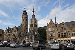
 Town Hall and St Nicholas Church | |
| Coordinates: 51°02′00″N 02°51′54″E / 51.03333°N 2.86500°E | |
| Country | |
| Community | Flemish Community |
| Region | Flemish Region |
| Province | West Flanders |
| Arrondissement | Diksmuide |
| Government | |
| • Mayor | Lies Laridon (CD&V) |
| • Governing party/ies | CD&V, Idee |
| Area | |
| • Total | 150.74 km2 (58.20 sq mi) |
| Population (2018-01-01)[1] | |
| • Total | 16,739 |
| • Density | 110/km2 (290/sq mi) |
| Postal codes | 8600 |
| NIS code | 32003 |
| Area codes | 051 |
| Website | www |
Diksmuide (Dutch pronunciation: [ˌdɪksˈmœydə] ; French: Dixmude, French pronunciation: [diksmyd]; West Flemish: Diksmude) is a Belgian city and municipality in the Flemish province of West Flanders. The municipality comprises the city of Diksmuide proper and the former communes of Beerst, Esen, Kaaskerke, Keiem, Lampernisse, Leke, Nieuwkapelle, Oostkerke, Oudekapelle, Pervijze, Sint-Jacobs-Kapelle, Stuivekenskerke, Vladslo and Woumen.
Most of the area west of the city is a polder riddled with drainage trenches. The major economic activity of the region is dairy farming, producing the famous butter of Diksmuide.
- ^ "Wettelijke Bevolking per gemeente op 1 januari 2018". Statbel. Retrieved 9 March 2019.


