Back East Brunswick Catalan East Brunswick (lungsod) CEB East Brunswick, New Jersey Welsh East Brunswick Township (New Jersey) German Municipio de East Brunswick (Nueva Jersey) Spanish برانزویک شرقی، نیوجرسی Persian East Brunswick (New Jersey) French East Brunswick, New Jersey HT East Brunswick (New Jersey) Italian イーストブランズウィック (ニュージャージー州) Japanese
East Brunswick, New Jersey | |
|---|---|
Busy Route 18 in East Brunswick, the geographical center of population of the U.S. state of New Jersey | |
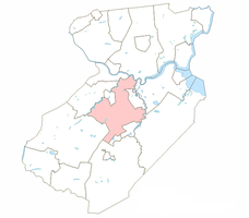
 Location of East Brunswick in Middlesex County highlighted in pink | |
 | |
Location in Middlesex County Location in New Jersey | |
| Coordinates: 40°25′34″N 74°25′06″W / 40.426249°N 74.418244°W[1][2] | |
| Country | |
| State | |
| County | Middlesex |
| Incorporated | February 28, 1860 |
| Government | |
| • Type | Faulkner Act (mayor–council) |
| • Body | Township Council |
| • Mayor | Brad J. Cohen (D, term ends December 31, 2024)[3][4] |
| • Administrator | Joseph Criscuolo[3] |
| • Municipal clerk | Tamar Lawful[5] |
| Area | |
| • Total | 22.36 sq mi (57.91 km2) |
| • Land | 21.78 sq mi (56.42 km2) |
| • Water | 0.57 sq mi (1.48 km2) 2.56% |
| • Rank | 123rd of 565 in state 6th of 25 in county[1] |
| Elevation | 131 ft (40 m) |
| Population | |
| • Total | 49,715 |
| • Estimate | 49,447 |
| • Rank | 38th of 565 in state 7th of 25 in county[11] |
| • Density | 2,282.2/sq mi (881.2/km2) |
| • Rank | 273rd of 565 in state 20th of 25 in county[11] |
| Time zone | UTC−05:00 (EST) |
| • Summer (DST) | UTC−04:00 (Eastern (EDT)) |
| ZIP Code | |
| Area code(s) | 732[14] |
| FIPS code | 3402319000[1][15][16] |
| GNIS feature ID | 0882163[1][17] |
| Website | www |
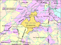
East Brunswick is a township in Middlesex County, in the U.S. state of New Jersey. The suburban bedroom community is part of the New York City metropolitan area and is located on the southern shore of the Raritan River, directly adjacent to the city of New Brunswick and located roughly 29 miles (47 km) away from New York City.[18][19][20] As of the 2020 United States census, the township's population was 49,715,[8][9] its highest decennial count ever and an increase of 2,203 (+4.6%) from the 2010 census count of 47,512,[21][22] which in turn reflected an increase of 756 (+1.6%) from the 46,756 counted in the 2000 census.[23]
East Brunswick was incorporated as a township by an act of the New Jersey Legislature on February 28, 1860, from portions of both Monroe Township and North Brunswick Township. Portions of the township were taken to form Washington town within the township (February 23, 1870; became independent as South River on February 28, 1898), Helmetta (March 20, 1888), Milltown (January 29, 1889) and Spotswood (April 15, 1908).[24]
Since the 2000 census, the United States Census Bureau calculated that New Jersey's center of population was located in the township.[25][26][27]
- ^ a b c d e 2019 Census Gazetteer Files: New Jersey Places, United States Census Bureau. Accessed July 1, 2020.
- ^ US Gazetteer files: 2010, 2000, and 1990, United States Census Bureau. Accessed September 4, 2014.
- ^ a b Mayor & Administrator, Township of East Brunswick. Accessed May 27, 2024.
- ^ 2023 New Jersey Mayors Directory, New Jersey Department of Community Affairs, updated February 8, 2023. Accessed February 10, 2023.
- ^ Township Clerk, Township of East Brunswick. Accessed May 27, 2024.
- ^ Cite error: The named reference
DataBookwas invoked but never defined (see the help page). - ^ U.S. Geological Survey Geographic Names Information System: Township of East Brunswick, Geographic Names Information System. Accessed March 5, 2013.
- ^ a b c Cite error: The named reference
Census2020was invoked but never defined (see the help page). - ^ a b Cite error: The named reference
LWD2020was invoked but never defined (see the help page). - ^ Cite error: The named reference
PopEstwas invoked but never defined (see the help page). - ^ a b Population Density by County and Municipality: New Jersey, 2020 and 2021, New Jersey Department of Labor and Workforce Development. Accessed March 1, 2023.
- ^ Look Up a ZIP Code for east Brunswick, NJ, United States Postal Service. Accessed January 4, 2012.
- ^ Zip Codes, State of New Jersey. Accessed September 9, 2013.
- ^ Area Code Lookup - NPA NXX for East Brunswick, NJ, Area-Codes.com. Accessed September 9, 2013.
- ^ U.S. Census website, United States Census Bureau. Accessed September 4, 2014.
- ^ Geographic Codes Lookup for New Jersey, Missouri Census Data Center. Accessed April 1, 2022.
- ^ US Board on Geographic Names, United States Geological Survey. Accessed September 4, 2014.
- ^ Raritan River Basin, Sierra Club, New Jersey Chapter - Raritan Valley Group. Accessed September 16, 2017. "The Raritan River proper forms at the confluence of the North Branch and the South Branch just west of Somerville. It flows 16 miles before slowing in tidewater at New Brunswick."
- ^ [1], Distance between cities. Accessed May 3, 2022.
- ^ Capuzzo, Jill P. "Living In: East Brunswick, N.J.: Community Gardens, Parks and Highways", The New York Times, May 13, 2015. Accessed May 3, 2022.
- ^ Cite error: The named reference
Census2010was invoked but never defined (see the help page). - ^ Cite error: The named reference
LWD2010was invoked but never defined (see the help page). - ^ Table 7. Population for the Counties and Municipalities in New Jersey: 1990, 2000 and 2010, New Jersey Department of Labor and Workforce Development, February 2011. Accessed May 1, 2023.
- ^ Snyder, John P. The Story of New Jersey's Civil Boundaries: 1606-1968, Bureau of Geology and Topography; Trenton, New Jersey; 1969. p. 170. Accessed June 11, 2012.
- ^ Sweilem, Amira. "N.J.’s population center still tilts north. This town considers it a badge of honor.", NJ Advance Media for NJ.com, November 27, 2022. Accessed January 20, 2024. "Answer time: East Brunswick has held the statistical center of population title since the 2010 Census.... The U.S. Census runs the calculation every 10 years and it has wobbled around Middlesex County since 1880, straying just once since that time into Somerset County (Warren Township) in 1890. East Brunswick just barely held onto the population center in the 2020 Census calculations.... The new spot is on Hawk Court just off Milltown Road between the NJ Turnpike and Ryders Lane."
- ^ Stirling, Stephen. "U.S. Census shows East Brunswick as statistical center of N.J.", The Star-Ledger, March 31, 2011. Accessed July 14, 2011. "For any of you who have ever lain awake at night asking: Where, oh where is the statistical center of New Jersey, there really is an answer. Nenninger Lane, East Brunswick. A few hundred feet into the woods along tiny Nenninger, a dead-end road beside the New Jersey Turnpike, sits the heart of the Garden State in terms of population, according to the U.S. Census Bureau."
- ^ "East Brunswick, N.J., Represents State's Population Center.", The Star-Ledger, March 27, 2001. Accessed September 17, 2007. "And the center of New Jersey, according to 2000 census data, is a litter-strewn patch of woods on Milltown Road in East Brunswick. Demographers call it the center of population, the place that would require the least amount of travel if all the state's 8.4 million residents were to converge on one spot.


