Back إسبيريتو سانتو Arabic Islla Espíritu Santo (Vanuatu) AST Эспірыту-Санта Byelorussian Еспириту Санто (остров) Bulgarian Santo aelan Bislama Espiritu Santo Catalan Espiritu Santo (pulo sa Wanatu) CEB Espiritu Santo Czech Espiritu Santo Danish Espiritu Santo German
This article needs additional citations for verification. (January 2023) |
You can help expand this article with text translated from the corresponding article in French. (November 2019) Click [show] for important translation instructions.
|
Nickname: Santo | |
|---|---|
 | |
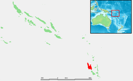
 Map of Espiritu Santo | |
| Geography | |
| Location | Sanma Province, Vanuatu |
| Coordinates | 15°25′S 166°54′E / 15.417°S 166.900°E |
| Archipelago | New Hebrides |
| Area | 3,955.5 km2 (1,527.2 sq mi) |
| Highest elevation | 1,879 m (6165 ft) |
| Highest point | Mount Tabwemasana |
| Administration | |
| Province | Sanma |
| Largest settlement | Luganville (pop. 10,738) |
| Demographics | |
| Population | 39,606 (2009) |
| Ethnic groups | Ni-Vanuatu |
Espiritu Santo[a] (UK: /ɛˌspɪrɪtuː ˈsæntoʊ/,[1] US: /- ˈsɑːntuː, - ˈsɑːntoʊ/;[2][3][4] French: [ɛspiʁity sɑ̃to]) is the largest island in the nation of Vanuatu, with an area of 3,955.5 km2 (1,527.2 sq mi) and a population of around 40,000 according to the 2009 census.[5]
Cite error: There are <ref group=lower-alpha> tags or {{efn}} templates on this page, but the references will not show without a {{reflist|group=lower-alpha}} template or {{notelist}} template (see the help page).
- ^ "Espiritu Santo". Collins English Dictionary. HarperCollins. Retrieved 13 August 2019.
- ^ "Espíritu Santo". The American Heritage Dictionary of the English Language (5th ed.). HarperCollins. Retrieved 13 August 2019.
- ^ "Espiritu Santo". Lexico US English Dictionary. Oxford University Press. Archived from the original on 2022-09-02.
- ^ "Espiritu Santo". Merriam-Webster.com Dictionary. Retrieved 13 August 2019.
- ^ 2009 Census Summary release final Archived December 21, 2013, at the Wayback Machine - Government of Vanuatu