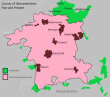
The administrative boundaries of Worcestershire, England have been fluid for over 150 years since the first major changes in 1844. There were many detached parts of Worcestershire in the surrounding counties, and conversely there were islands of other counties within Worcestershire. The 1844 Counties (Detached Parts) Act began the process of eliminating these, but the process was not completed until 1966, when Dudley was absorbed into Staffordshire.
The expansion of Birmingham and the Black Country during and after the Industrial Revolution also altered the county map considerably. Local government commissions were set up to recommend changes to the local government structures, and as early as 1945 recommendations were made to merge Worcestershire with Herefordshire. Eventually in 1974, a form of this recommendation was carried out, most of Worcestershire was combined with Herefordshire to form a new county named Hereford and Worcester, while the northern Black Country towns and villages of Worcestershire, along with adjoining areas of Staffordshire and Warwickshire, formed the new administrative county of West Midlands.
Hereford & Worcester was re-divided into the separate counties of Herefordshire and Worcestershire in 1998. Since that time Worcestershire's boundaries have not changed. Redditch opted to join the West Midlands Combined Authority as an associate 'non-constituent' member in October 2015, although this will not affect the borough's status within Worcestershire.
