Back فورت إيري (أونتاريو) Arabic فورت ايرى ARZ Fort Érié ATJ Fort Erie BAR Fort Erie CEB Fort Erie German Fort Erie Spanish فورت اری (انتاریو) Persian Fort Érié (Ontario) French Fort Erie (Ontario) Italian
This article needs additional citations for verification. (April 2011) |
Fort Erie
Fort-Érié (French) | |
|---|---|
| Town of Fort Erie | |
 Fort Erie | |
| Coordinates: 42°55′N 79°01′W / 42.917°N 79.017°W | |
| Country | |
| Province | |
| Regional Municipality | Niagara |
| Government | |
| • Mayor | Wayne H. Redekop |
| • Governing body | Fort Erie Town Council |
| • MP | Tony Baldinelli |
| • MPP | Wayne Gates |
| Area | |
| • Land | 166.27 km2 (64.20 sq mi) |
| Population (2016)[1] | |
| • Total | 30,710 |
| • Density | 184.7/km2 (478/sq mi) |
| Time zone | UTC-5 (EST) |
| • Summer (DST) | UTC-4 (EDT) |
| Forward Sortation Area | |
| Area code(s) | 905, 289, 365, and 742 |
| Highways | |
| Website | www.forterie.ca |
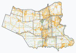
Fort Erie is a town in the Niagara Region of Ontario, Canada. The town is located at the south eastern corner of the region, on the Niagara River, directly across the Canada–United States border from Buffalo, New York, and is the site of Old Fort Erie which played a prominent role in the War of 1812.
Fort Erie is one of Niagara's fastest growing communities, and has experienced a high level of residential and commercial development in the past few years. Garrison Road (Niagara Regional Road 3) is the town's commercial corridor, stretching east to west through Fort Erie.
Fort Erie is also home to other commercial core areas (Bridgeburg, Ridgeway, Stevensville and Crystal Beach) as a result of the 1970 amalgamation of Bertie Township and the village of Crystal Beach with Fort Erie.
Crystal Beach Park occupied waterfront land at Crystal Beach, Ontario, from 1888 until the park's closure in 1989. The beach is part of Fort Erie.[2]
- ^ a b 2016 Census Profile
- ^ "Crystal Beach". forteriecanada.com. Retrieved 7 September 2017.

