Back Xeografía d'El Salvador AST География на Салвадор Bulgarian এল সালভাদোরের ভূগোল Bengali/Bangla Geografía de El Salvador Spanish جغرافیای السالوادور Persian Géographie du Salvador French Geografi El Salvador ID Geografia Salwadoru Polish Geografia de El Salvador Portuguese География Сальвадора Russian
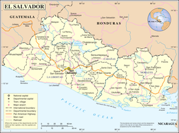
El Salvador is a country in Central America. Situated at the meeting point of three tectonic plates, it is highly seismologically active and the location of numerous earthquakes and volcanic eruptions. The country has a tropical climate.
 | |
| Continent | North America |
|---|---|
| Region | Central America |
| Area | Ranked 148th |
| • Total | 21,041 km2 (8,124 sq mi) |
| • Land | 98.48% |
| • Water | 1.52% |
| Coastline | 307 km (191 mi) |
| Borders | Total border: 590 km (370 mi) |
| Highest point | Cerro El Pital 2,730 metres (8,960 ft) |
| Lowest point | Pacific Ocean 0 metres (0 ft) |
| Longest river | Rio Lempa 422 km (262 mi) |
| Largest lake | Lago de Ilopango 72 km2 (28 sq mi) |
| Exclusive economic zone | 90,962 km2 (35,121 sq mi) |