Back Gers Afrikaans Département Gers ALS Gers AN جارس (إقليم فرنسي) Arabic Jer (departament) Azerbaijani Жэр (дэпартамент) Byelorussian Жэр (дэпартамэнт) BE-X-OLD Жерс (департамент) Bulgarian Gers (departamant) Breton Gers Catalan
Gers | |
|---|---|
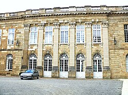
 Prefecture building in Auch | |
 Location of Gers in France | |
| Coordinates: 43°39′N 0°35′E / 43.650°N 0.583°E | |
| Country | France |
| Region | Occitanie |
| Prefecture | Auch |
| Subprefectures | Condom Mirande |
| Government | |
| • President of the Departmental Council | Philippe Dupouy[1] (PS) |
| Area | |
| • Total | 6,257 km2 (2,416 sq mi) |
| Population (2021)[2] | |
| • Total | 192,437 |
| • Rank | 90th |
| • Density | 31/km2 (80/sq mi) |
| Time zone | UTC+1 (CET) |
| • Summer (DST) | UTC+2 (CEST) |
| Department number | 32 |
| Arrondissements | 3 |
| Cantons | 17 |
| Communes | 461 |
| ^1 French Land Register data, which exclude estuaries, and lakes, ponds, and glaciers larger than 1 km2 | |
Gers (French pronunciation: [ʒɛʁ(s)]; Occitan: Gers or Gerç, [dʒɛɾs]) is a department in the region of Occitania, Southwestern France. Gers becoming the largest producer of foie gras in France, known for its rural scene and bastides. Gers is bordered by the departments of Hautes-Pyrénées and Pyrénées-Atlantiques to the south, Haute-Garonne and Tarn-et-Garonne to the east, Lot-et-Garonne to the north and Landes to the west.[3] Named after the Gers River, its inhabitants are called the Gersois and Gersoises in French. In 2019, it had a population of 191,377.[4]
- ^ "Philippe Dupouy succède à Philippe Martin à la tête du département du Gers". France 3. 25 January 2022.
- ^ "Téléchargement du fichier d'ensemble des populations légales en 2021" (in French). The National Institute of Statistics and Economic Studies. 28 December 2023.
- ^ Chisholm, Hugh, ed. (1911). . Encyclopædia Britannica. Vol. 11 (11th ed.). Cambridge University Press. p. 904.
- ^ Populations légales 2019: 32 Gers, INSEE

