Back مقاطعة هري بور Arabic হরিপুর জেলা Bengali/Bangla Districte d'Haripur Catalan Harīpur District CEB Haripur (Distrikt) German ناحیه هریپور Persian District d'Haripur French हरिपुर ज़िला Hindi हरिपुर जिला MAI Dystrykt Haripur Polish
Haripur District
ضلع ہری پور | |
|---|---|
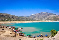
Top: Khanpur Dam Bottom: Buddhist remains at Badalpur | |
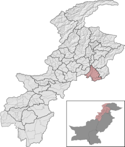
 Haripur District (red) in Khyber Pakhtunkhwa | |
| Country | Pakistan |
| Province | Khyber Pakhtunkhwa |
| Division | Hazara |
| Headquarters | Haripur |
| Government | |
| • Type | District Administration |
| • Deputy Commissioner | N/A |
| • District Police Officer | N/A |
| • District Health Officer | N/A |
| Area | |
| • Total | 1,725 km2 (666 sq mi) |
| Population (2023)[1] | |
| • Total | 1,174,783 |
| • Density | 680/km2 (1,800/sq mi) |
| Time zone | UTC+5 (PST) |
| Number of Tehsils | 3 |
| languages | Hindko • Pashto • Urdu |
| Website | haripur |
Haripur District (Hindko, Urdu: ضلع ہری پور) is a district in the Hazara Division of Khyber Pakhtunkhwa, Pakistan.
Before obtaining the status of a district in 1991, Haripur was a tehsil of Abbottabad District.[2][3]: 5 Its headquarters are the city of Haripur.
- ^ Cite error: The named reference
2017censuswas invoked but never defined (see the help page). - ^ "Haripur District population per 2017 census of Pakistan". Citypopulation.de website. Archived from the original on 29 April 2020. Retrieved 29 October 2023.
- ^ 1998 District Census report of Haripur. Census publication. Vol. 91. Islamabad: Population Census Organization, Statistics Division, Government of Pakistan. 2000.

