Back Hendaia AN أونداي Arabic اونداى ARZ Hendaia AST Hendaye Azerbaijani Андай Byelorussian Hendaia Breton Hendaia Catalan Андай CE Hendaye CEB
Hendaye
Hendaia | |
|---|---|
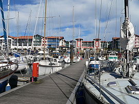
 Hendaye harbour | |
| Coordinates: 43°22′N 1°46′W / 43.36°N 1.77°W | |
| Country | France |
| Region | Nouvelle-Aquitaine |
| Department | Pyrénées-Atlantiques |
| Arrondissement | Bayonne |
| Canton | Hendaye-Côte Basque-Sud |
| Intercommunality | CA Pays Basque |
| Government | |
| • Mayor (2020–2026) | Kotte Écénarro[1] |
| Area 1 | 8 km2 (3 sq mi) |
| Population (2021)[2] | 17,796 |
| • Density | 2,200/km2 (5,800/sq mi) |
| Time zone | UTC+01:00 (CET) |
| • Summer (DST) | UTC+02:00 (CEST) |
| INSEE/Postal code | 64260 /64700 |
| Elevation | 0–108 m (0–354 ft) (avg. 25 m or 82 ft) |
| 1 French Land Register data, which excludes lakes, ponds, glaciers > 1 km2 (0.386 sq mi or 247 acres) and river estuaries. | |
Hendaye (French pronunciation: [ɑ̃daj]; Basque: Hendaia,[3] Spanish: Hendaya) is a commune in the Pyrénées-Atlantiques department and Nouvelle-Aquitaine region of southwestern France.[4]
The town, Metropolitan France's most southwesterly and a popular seaside tourist resort, stands on the right bank of the River Bidassoa – which marks the Franco-Spanish border – at the point where it empties into the Atlantic Ocean in the French Basque Country.
Hendaye has three distinguishable parts: la ville (the town), which stretches from Saint Vincent's church to the area around the SNCF railway station and the industrial zone; la plage (the beach), the seaside quarter; and les hauteurs (the heights), the villas and camping sites on the hills between and behind the other two areas.
- ^ "Répertoire national des élus: les maires". data.gouv.fr, Plateforme ouverte des données publiques françaises (in French). 2 December 2020.
- ^ "Populations légales 2021" (in French). The National Institute of Statistics and Economic Studies. 28 December 2023.
- ^ HENDAIA, Auñamendi Eusko Entziklopedia (in Spanish)
- ^ INSEE commune file


