Back جبل المكبر Arabic Džebel Mukabir Czech Jabel Mukaber Spanish جبل مکبر Persian ג'בל מוכאבר HE Jabel Mukaber NB
Jabel Mukaber | |
|---|---|
| Arabic transcription(s) | |
| • Arabic | جبل مكبر |
| • Latin | Jabal Mukaber Jabel Muqaber Jabal Mukkaber (unofficial) |
| Hebrew transcription(s) | |
| • Hebrew | ג'בל מוכאבר |
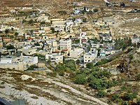
 Jabel Mukaber with the Dome of the Rock seen in the background. | |
Location of Jabel Mukaber within Palestine | |
| Coordinates: 31°45′17″N 35°14′28″E / 31.75472°N 35.24111°E | |
| State | State of Palestine |
| Governorate | Jerusalem |
| Occupying state | Israel |
| Israeli district | Jerusalem District |
| Government | |
| • Type | Municipality |
| Population | |
| • Total | 16,030 |


Jabel Mukaber (Arabic: جبل مكبر, Hebrew: ג'בל מוכאבר) is a predominantly Palestinian neighborhood in southern East Jerusalem.[1] It is bordered by East Talpiot[2] to the west, Abu Tor and Silwan to the north and Sur Baher to the south. Jabel Mukaber has a population of approximately 30,000 (2017).[3][2]
- ^ "Israel approves major settlement expansion in Palestinian neighborhood in East Jerusalem". haaretz.com. 2017-10-25. Retrieved 2019-05-31.
- ^ a b Segev, Tom (1 September 2005). "A good friend jumps the fence - Haaretz.co.il". Haaretz Daily Newspaper Ltd. Retrieved 2011-07-17.
- ^ Cite error: The named reference
Shalomwas invoked but never defined (see the help page).

