Back Kabayan BCL Kabayan CBK-ZAM Kabayan, Benguet CEB Kabayan German Kabayan Spanish Kabayan French Kabayan, Benguet ID Kabayan ILO Kabayan Italian კაბაიანი (ბენგეტი) Georgian
Kabayan | |
|---|---|
| Municipality of Kabayan | |
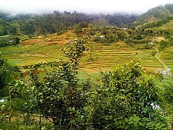
 Rice terraces | |
 Map of Benguet with Kabayan highlighted | |
Location within the Philippines | |
| Coordinates: 16°37′24″N 120°50′17″E / 16.6233°N 120.8381°E | |
| Country | Philippines |
| Region | Cordillera Administrative Region |
| Province | Benguet |
| District | Lone district |
| Barangays | 13 (see Barangays) |
| Government | |
| • Type | Sangguniang Bayan |
| • Mayor | Florante B. Bantales Jr. |
| • Vice Mayor | Mike E. Badival |
| • Representative | Eric Go Yap |
| • Electorate | 10,092 voters (2022) |
| Area | |
| • Total | 242.69 km2 (93.70 sq mi) |
| Elevation | 1,613 m (5,292 ft) |
| Highest elevation | 2,688 m (8,819 ft) |
| Lowest elevation | 932 m (3,058 ft) |
| Population (2020 census)[3] | |
| • Total | 15,806 |
| • Density | 65/km2 (170/sq mi) |
| • Households | 3,752 |
| Economy | |
| • Income class | 4th municipal income class |
| • Poverty incidence | 11.34 |
| • Revenue | ₱ 116.2 million (2020) |
| • Assets | ₱ 231.1 million (2020) |
| • Expenditure | ₱ 92.33 million (2020) |
| • Liabilities | ₱ 56.5 million (2020) |
| Service provider | |
| • Electricity | Benguet Electric Cooperative (BENECO) |
| Time zone | UTC+8 (PST) |
| ZIP code | 2606 |
| PSGC | |
| IDD : area code | +63 (0)74 |
| Native languages | Kankanaey Ibaloi Ilocano Tagalog |
Kabayan, officially the Municipality of Kabayan (Ilocano: Ili ti Kabayan; Tagalog: Bayan ng Kabayan), is a 4th class municipality in the province of Benguet, Philippines. According to the 2020 census, it has a population of 15,806 people.[3]
Kabayan is the site of centuries-old Ibaloi mummies buried inside caves scattered around its villages.[5]
The third highest mountain in the Philippines, Mount Pulag, is located in the territorial boundary of the vegetable farming town.
- ^ Municipality of Kabayan | (DILG)
- ^ "2015 Census of Population, Report No. 3 – Population, Land Area, and Population Density" (PDF). Philippine Statistics Authority. Quezon City, Philippines. August 2016. ISSN 0117-1453. Archived (PDF) from the original on May 25, 2021. Retrieved July 16, 2021.
- ^ a b Census of Population (2020). "Cordillera Administrative Region (CAR)". Total Population by Province, City, Municipality and Barangay. Philippine Statistics Authority. Retrieved July 8, 2021.
- ^ "PSA Releases the 2021 City and Municipal Level Poverty Estimates". Philippine Statistics Authority. April 2, 2024. Retrieved April 28, 2024.
- ^ "Kabayan Mummies". Mummy Tombs. Archived from the original on October 28, 2000. Retrieved September 17, 2014.


