Back Land Hadeln German Land Hadeln Spanish Land Hadeln Estonian Pays de Hadeln French Hodelerlân Frisian Land Hadeln NDS Land Hadeln Dutch Хадельн Russian Land Hadeln SIMPLE


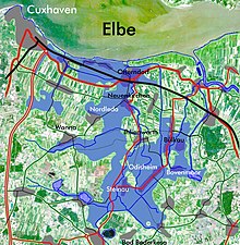
Land Hadeln is a historic landscape and former administrative district in Northern Germany with its seat in Otterndorf on the Lower Elbe, the lower reaches of the River Elbe, in the Elbe-Weser Triangle between the estuaries of the Elbe and Weser.
The name goes back to a place named Haduloha in the Royal Frankish Annals,[1] which must have been in the north of Hohe Lieth moraine range, west of present-day Cuxhaven. Enthusiastic historians of late 19th and early 20th century postulated an Old Saxon Gau (district) of that name, but there is no evidence for this theory.[2]
In the Middle Ages, the Land Hadeln was a fairly, but not perfectly, autonomous rural community, applying Saxon Law. Nominally, it belonged to the Dukes of Saxe-Lauenburg, whom the notables of the country almost had chosen, because they were too weak to rule strictly.
The Land Hadeln has to be consequently distinguished from the Land Wursten west of it that was a perfectly autonomous rural republic, for some centuries. It was the easternmost of the Frisian republics and applied Frisian Law.
- ^ ANNALES REGNI FRANCORUM online (in Latin)]
- ^ Hans-Ulrich Hucker: Das Problem von Herrschaft und Freiheit in den Landesgemeinden des Mittelalters im Unterweserraum (Thesis, Münster 1978), available in Staatsarchiv Bremen (n°. 538 U) und in the Library of Männer vom Morgenstern historical society in Bremerhaven