Back لانزدوون، مریلند AZB Lansdowne (lungsod sa Tinipong Bansa, Maryland) CEB Lansdowne (Maryland) Spanish Lansdowne (Maryland) Basque لنزداون، مریلند Persian Lansdowne (Maryland) Hungarian Lansdowne (Maryland) LLD Lansdowne (Maryland) Polish Lansdowne, Maryland Serbo-Croatian Лансдаун (Мериленд) Serbian
Lansdowne, Maryland | |
|---|---|
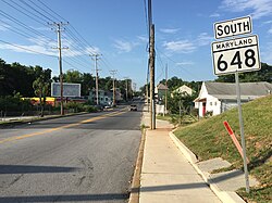
 View south along Maryland State Route 648 (Annapolis Road) entering Lansdowne | |
 Location of Lansdowne in Maryland | |
| Coordinates: 39°14′35″N 76°39′30″W / 39.24306°N 76.65833°W | |
| Country | |
| State | |
| County | |
| Established | 1892[1] |
| Area | |
| • Total | 2.40 sq mi (6.23 km2) |
| • Land | 2.28 sq mi (5.90 km2) |
| • Water | 0.13 sq mi (0.33 km2) |
| Population (2020) | |
| • Total | 9,004 |
| • Density | 3,956.06/sq mi (1,527.19/km2) |
| Time zone | UTC−5 (Eastern (EST)) |
| • Summer (DST) | UTC−4 (EDT) |
| ZIP code | 21227 |
| Area code | 410 and 443 |
| FIPS code | 24-45650 |
Lansdowne is a census-designated place in southern Baltimore County, Maryland, United States, located just south of Baltimore. As of the 2010 census, it had a population of 8,409.[3] At the 2000 census and earlier, the area was delineated as part of the Lansdowne-Baltimore Highlands CDP.
- ^ . May 18, 2014 https://web.archive.org/web/20140518050030/http://www.postalmuseum.si.edu/statepostalhistory/Maryland_Post_Offices.pdf. Archived from the original on May 18, 2014. Retrieved April 24, 2018.
{{cite web}}: Missing or empty|title=(help)CS1 maint: bot: original URL status unknown (link) - ^ "2020 U.S. Gazetteer Files". United States Census Bureau. Retrieved April 26, 2022.
- ^ "Profile of General Population and Housing Characteristics: 2010 Demographic Profile Data (DP-1): Lansdowne CDP, Maryland". United States Census Bureau. Retrieved February 21, 2012.
