Back Linth ALS نهر لينث ARZ Линт (река) Bulgarian Linth Catalan Linth German Linth Esperanto Río Linth Spanish Linth Basque Linth Finnish Linth French
| Linth | |
|---|---|
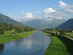
 The lower reaches of the Linth near Reichenburg | |
| Location | |
| Country | Switzerland |
| Physical characteristics | |
| Source | |
| • location | Canton of Glarus, Switzerland |
| Mouth | |
• location | Lake Zurich (Obersee) |
• coordinates | 47°13′06″N 8°56′27″E / 47.2183°N 8.9407°E |
| Length | 50 kilometres (31 mi) |
| Basin features | |
| Progression | Lake Zurich→ Limmat→ Aare→ Rhine→ North Sea |
The Linth (pronounced [ˈlɪnt] "lint") is a Swiss river that rises near the village of Linthal in the mountains of the canton of Glarus, and eventually flows into the Obersee section of Lake Zurich. It is about 50 kilometres (31 mi) in length.[1]
The water power of the Linth was a main factor in the creation of the textile industry of the canton Glarus, and is today used to drive the Linth–Limmern power stations in its upper reaches.
The river and its upper valley forms the boundary between the mountain ranges of the Glarus Alps, to its east and south, and the Schwyzer Alps, to its west.
- ^ map.geo.admin.ch (Map). Swiss Confederation. Retrieved 2015-04-27.