Back نهر ميلرز ARZ Millers River (suba sa Tinipong Bansa, Franklin County) CEB Millers River Czech Millers River German
| Millers River | |
|---|---|
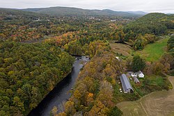
 Millers River at Millers Falls, Massachusetts | |
| Physical characteristics | |
| Source | |
| • location | Confluence of Bear Meadow Brook and Bluefield Brook, Ashburnham, Massachusetts |
| • elevation | 1,124 feet (343 m) |
| Mouth | |
• location | Connecticut River at Millers Falls, Massachusetts |
• elevation | 175 feet (53 m) |
| Length | 52 miles (84 km) |
| Basin size | 390 square miles (1,000 km2) |
| Discharge | |
| • average | 1,000 cu ft/s (28 m3/s) |
The Millers River is a 52.1-mile-long (83.8 km)[1] river in northern Massachusetts, originating in Ashburnham[2] and joining the Connecticut River just downstream from Millers Falls, Massachusetts. Sections of the river are used for whitewater kayaking, and a section upriver is popular with flatwater racers (canoe racing), and the river is known locally as a good place for pike fishing.
- ^ U.S. Geological Survey. National Hydrography Dataset high-resolution flowline data. The National Map Archived March 29, 2012, at the Wayback Machine, accessed April 1, 2011
- ^ "TopoQuest map for main branch". Retrieved June 29, 2008.