Back Propinsi Bulubundukin ACE مقاطعة ماونتين Arabic ماونتین (فیلیپین) AZB Mountain Province BCL Mountain Province CBK-ZAM Mountain Province CEB Mountain Province German Provincia de La Montaña Spanish Mountain probintzia Basque ماونتین (فیلیپین) Persian
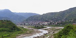
Mountain Province (Filipino: Lalawigang Bulubundukin[3]) is a landlocked province of the Philippines in the Cordillera Administrative Region in Luzon. Its capital is Bontoc. Mountain Province was formerly referred to as Mountain in some foreign references. The name is usually shortened by locals to Mt. Province.
The province was named so for being in the Cordillera Central mountain range found in the upper realms of Luzon island.
Mountain Province was also the name of the historical province that included most of the current Cordillera provinces. This old province was established by the Philippine Commission in 1908,[4][5][6] and was later split in 1966 into Mountain Province, Benguet, Kalinga-Apayao and Ifugao.[7][8][9]
The province is also known for its mummy caves, which contain naturally mummified bodies, and for its hanging coffins.[7]
- ^ "List of Provinces". PSGC Interactive. Makati, Philippines: National Statistical Coordination Board. Retrieved December 23, 2013.
- ^ Census of Population (2020). Table B - Population and Annual Growth Rates by Province, City, and Municipality - By Region. Philippine Statistics Authority. Retrieved July 8, 2021.
- ^ Tamanio-Yraola, Marialita (1979). "Ang Musika Ng Mga Bontok Igorot Sa Sadanga, Lalawigang Bulubundukin: Unang Bahagi". Musika Jornal (in Filipino) (3): 109–111. Retrieved June 29, 2024.
- ^ Worcester, Dean C.; Philippine Commission (1908). Seventh Annual Report of the Secretary of the Interior to the Philippine Commission for the Fiscal Year Ended June 30, 1908 (Digitized by Google on 23 Nov 2005 (Original file from the University of Michigan)). Manila: U.S. Government Printing Office. pp. 17–19. Retrieved January 2, 2015.
- ^ Keesing, Felix Maxwell; Keesing, Marie Margaret; Keesing, Marie Martin; Institute of Pacific Relations (contributor); International Research Committee (contributor) (1934). Taming Philippine Headhunters: A Study of Government and of Cultural Change in Northern Luzon. Stanford University Press. p. 69. ISBN 9780804721103. Retrieved January 2, 2015.
- ^ Cite error: The named reference
1908TheWaywas invoked but never defined (see the help page). - ^ a b Lancion, Conrado M. Jr.; de Guzman, Rey (cartography) (1995). "The Provinces". Fast Facts about Philippine Provinces (The 2000 Millenium ed.). Makati, Metro Manila: Tahanan Books. pp. 108–109. ISBN 971-630-037-9. Retrieved January 16, 2015.
- ^ "Natural Attractions found in Atok". Province of Benguet. Retrieved August 13, 2013.
- ^ Cite error: The named reference
ChanRobleswas invoked but never defined (see the help page).


