Back نيزاماباد ديستريكت ARZ निजामाबाद जिला Bihari নিজামাবাদ (আজমগড়) BPY Districte de Nizamabad Catalan Nizamabad District CEB Nizamabad (Distrikt) German Distrito de Nizamabad Spanish Nizamabad barrutia Basque بخش نظامآباد Persian Nizamabadin piirikunta Finnish
Nizamabad district
Induru | |
|---|---|
 Nizamabad Fort Entrance | |
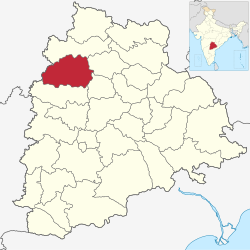
 Location in Telangana | |
| State | Telangana |
| Mandalas | 29 |
| Founded | 1905 |
| Headquarters | Nizamabad |
| Government | |
| • Body | Zilla Parishad |
| • MLA (Urban) | Sri Dhanpal Suryanarayana |
| • MLA (Rural) | Sri Bhoopathi Reddy Rekulapally |
| Area | |
| • Total | 4,288 km2 (1,656 sq mi) |
| • Rank | 10th (in state) |
| Population (2011)[1] | |
| • Total | 1,571,022 |
| • Rank | 5th |
| • Density | 370/km2 (950/sq mi) |
| Demonym | Nizamabadi |
| Languages | |
| • Official | Telugu, Urdu |
| Time zone | UTC+5:30 (IST) |
| PIN | 503 xxx |
| Telephone code | +91-08462 |
| Vehicle registration | TS 16[2] |
| Website | nizamabad |
Nizamabad district is a district located in the north-western region of the Indian state of Telangana. The city of Nizamabad is the district headquarters. The district share boundaries with Jagtial, Sircilla, Nirmal, Kamareddy districts and with Nanded district of the state boundary of Maharashtra.
- ^ a b "New districts". Andhra Jyothy.com. 8 October 2016. Retrieved 8 October 2016.
- ^ "District Codes". Government of Telangana Transport Department. Retrieved 4 September 2014.
