Back خزان أوجالا الجوفي Arabic Ogallala-Aquifer German Ogallala-grundakvejo Esperanto Ogallalan akviferi Finnish Aquifère Ogallala French オガララ帯水層 Japanese 오갈랄라 대수층 Korean ഒഗാല്ലല ഭൂഗർഭജലശേഖരം Malayalam Aquífero de Ogallala Portuguese 奥加拉拉蓄水层 Chinese


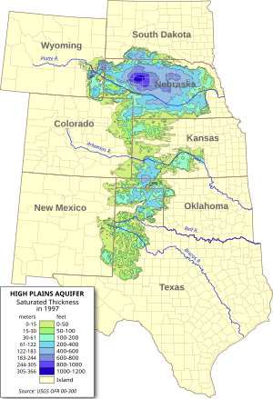
The Ogallala Aquifer (oh-gə-LAH-lə) is a shallow water table aquifer surrounded by sand, silt, clay, and gravel located beneath the Great Plains in the United States. As one of the world's largest aquifers, it underlies an area of approximately 174,000 sq mi (450,000 km2) in portions of eight states (South Dakota, Nebraska, Wyoming, Colorado, Kansas, Oklahoma, New Mexico, and Texas).[1] It was named in 1898 by geologist N. H. Darton from its type locality near the town of Ogallala, Nebraska. The aquifer is part of the High Plains Aquifer System, and resides in the Ogallala Formation, which is the principal geologic unit underlying 80% of the High Plains.[2][3]
Large-scale extraction for agricultural purposes started after World War II due partially to center pivot irrigation and to the adaptation of automotive engines to power groundwater wells.[4] Today about 27% of the irrigated land in the entire United States lies over the aquifer, which yields about 30% of the ground water used for irrigation in the United States.[5] The aquifer is at risk of over-extraction and pollution. Since 1950, agricultural irrigation has reduced the saturated volume of the aquifer by an estimated 9%. Once depleted, the aquifer will take over 6,000 years to replenish naturally through rainfall.[6]
The aquifer system supplies drinking water to 82% of the 2.3 million people (1990 census) who live within the boundaries of the High Plains study area.[7]
- ^ Mcguire, V.L. (May 2007). "Changes in Water Levels and Storage in the High Plains Aquifer, Predevelopment to 2005". USGS Fact Sheet 2007-3029. USGS. Retrieved August 12, 2009.
- ^ Darton, N. H. (1903). "Preliminary report on the geology and water resources of Nebraska west of the one hundred and third meridian". USGS Professional Paper 17. Government Printing Office. doi:10.3133/pp17. hdl:2346/61709. Retrieved August 14, 2022.
- ^ Rex C. Buchanan; B. Brownie Wilson; Robert R. Buddemeier; James J. Butler Jr. "The High Plains Aquifer". Kansas Geological Survey, Public Information Circular (PIC) 18.
- ^ Hornbeck, Richard; Pinar Keskin (September 2012). "The Historically Evolving Impact of the Ogallala Aquifer: Agricultural Adaptation to Groundwater and Drought" (PDF). Harvard Environmental Economics Program. Cambridge. Retrieved October 2, 2016.
- ^ "Ogallala Aquifer Initiative 2011 Report" (PDF). Natural Resources Conservation Service. United States Department of Agriculture. 2011. Archived from the original (PDF) on May 2, 2022. Retrieved October 2, 2016.
- ^ Plumer, B. (2012). "Where the world's running out of water, in one map". Washington Post. Retrieved August 18, 2014.
- ^ Dennehy, K.F. (2000). "High Plains regional ground-water study: U.S. Geological Survey Fact Sheet FS-091-00" (PDF). USGS. Retrieved May 7, 2008.