Back Lido di Ostia CEB Lido di Ostia German Ostia (nuntempa) Esperanto اوستیا (رم) Persian Ostie (ville) French Ostia Hungarian Ostia (Roma) Italian オスティア Japanese 오스티아 Korean Ostia (frazione) Dutch
This article needs additional citations for verification. (October 2015) |
Ostia | |
|---|---|
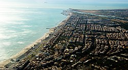
 Aerial view of Ostia, with the Tiber and its mouth in the background | |
| Coordinates: 41°43′59.68″N 12°16′44.18″E / 41.7332444°N 12.2789389°E | |
| Country | |
| Region | Lazio |
| Province | Metropolitan City of Rome Capital |
| Comune | Rome |
| Elevation | 5 m (16 ft) |
| Population (2010) | |
| • Total | 85,301 |
| Demonym | Lidensi/Ostiensi |
| Time zone | UTC+1 (CET) |
| • Summer (DST) | UTC+2 (CEST) |
| Postal code | 00121 - 00122 |
| Dialing code | 06 |
Ostia (/ˈɒstiə/, Italian: [ˈɔstja]; officially Lido di Ostia) is a large neighbourhood in the Municipio X of the comune of Rome, Italy, near the ancient port of Rome, which is now a major archaeological site known as Ostia Antica.[1] Ostia is also the only municipio or district of Rome on the Tyrrhenian Sea, and many Romans spend the summer holidays there. It is entirely situated within the municipality of Rome and is the city's seaside resort.
Ostia was the port city of ancient Rome, it had a strategic function for trade, especially for the supply of grain, and as the main base of the Roman navy. It was also a service port for ships heading to Portus. The ancient city of Ostia stood in a strategic point near the mouth of the Tiber and the sea, which at the time was closer to the city. The modern seaside resort, Lido di Ostia, is in fact located about 5 km (3 miles) south-west of the ancient city and about 28 km from Rome (17.4 miles).
- ^ "Ostia - Italy, Map, History, & Facts". britannica.com. Retrieved 2020-01-01.

