Back مقاطعة أوتيرو (كولورادو) Arabic Otero County, Colorado BAR Атэра (акруга, Каларада) Byelorussian Отеро (окръг, Колорадо) Bulgarian ওটেরো কাউন্টি, কলোরাডো BPY Otero Gông (Colorado) CDO Отеро (гуо, Колорадо) CE Otero County (kondado sa Tinipong Bansa, Colorado) CEB Otero County (Colorado) Czech Otero County, Colorado Welsh
Otero County | |
|---|---|
 Otero County Courthouse in La Junta | |
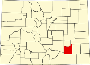
 Location within the U.S. state of Colorado | |
 Colorado's location within the U.S. | |
| Coordinates: 37°54′N 103°43′W / 37.9°N 103.71°W | |
| Country | |
| State | |
| Founded | March 25, 1889 |
| Named for | Miguel Antonio Otero |
| Seat | La Junta |
| Largest city | La Junta |
| Area | |
| • Total | 1,270 sq mi (3,300 km2) |
| • Land | 1,262 sq mi (3,270 km2) |
| • Water | 7.7 sq mi (20 km2) 0.6% |
| Population (2020) | |
| • Total | 18,690 |
| • Density | 15/sq mi (6/km2) |
| Time zone | UTC−7 (Mountain) |
| • Summer (DST) | UTC−6 (MDT) |
| Congressional district | 3rd |
| Website | oterocounty |


Otero County is a county located in the U.S. state of Colorado. As of the 2020 census, the population was 18,690.[1] The county seat is La Junta.[2] The county was named for Miguel Antonio Otero, one of the founders of the town of La Junta and a member of a prominent Hispanic family.
- ^ "State & County QuickFacts". United States Census Bureau. Retrieved September 5, 2021.
- ^ "Find a County". National Association of Counties. Retrieved June 7, 2011.