Back ولاتة Arabic Oualata AST Oualata AVK Oualata Catalan Oualata Danish Oualata German Ualata Spanish Oualata Basque Oualata Finnish Oualata French
Oualata
Arabic: ولاتة | |
|---|---|
Commune and town | |
 View of the town looking in a southeasterly direction | |
| Coordinates: 17°18′00″N 7°01′30″W / 17.3°N 7.025°W | |
| Country | Mauritania |
| Region | Hodh Ech Chargui |
| Population (2013 census)[1] | |
| • Total | 13,086 |
| Official name | Ancient Ksour of Ouadane, Chinguetti, Tichitt and Oualata |
| Type | Cultural |
| Criteria | iii, iv, v |
| Designated | 1996 (20th session) |
| Reference no. | 750 |
| Region | Arab States |

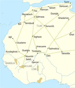
Oualata or Walata (Arabic: ولاتة) (also Biru in 17th century chronicles)[2] is a small oasis town in southeast Mauritania, located at the eastern end of the Aoukar basin. Oualata was important as a caravan city in the thirteenth and fourteenth centuries as the southern terminus of a trans-Saharan trade route and now it is a World Heritage Site.
- ^ "Oualata (Agricultural Urban Commune, Mauritania) - Population Statistics, Charts, Map and Location". www.citypopulation.de. Retrieved 2024-02-15.
- ^ Hunwick 1999, p. 9 n4. Walata is the arabized form of the Manding wala meaning a "shady place" while Biru is the Soninke word and has a similar meaning.
