Back بالماس Arabic بالماس ARZ Палмас Byelorussian Палмас (Токантинс) Bulgarian পালমাস BPY Palmas (Tocantins) Catalan Палмас CE Palmas (munisipyo sa Brasil, Tocantins, lat -10,12, long -48,08) CEB Palmas Czech Palmas German
Palmas | |
|---|---|
| Município de Palmas Municipality of Palmas | |
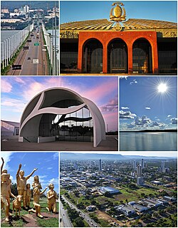
 From the top; clockwise: Tocantins River Bridge; Araguaia Palace; Tocantins River; Aerial view of Palmas; Súplica dos Pioneiros monument and Coluna Prestes Memorial. | |
| Nickname: Capital Ecológica (Ecological Capital) | |
| Motto(s): Co Yvy Ore Retama (Tupi for 'This Land is Ours'; in Portuguese: Esta Terra é Nossa) | |
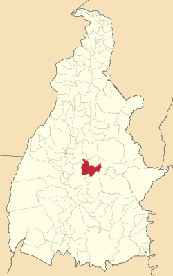
 Localization of Palmas in Tocantins | |
| Coordinates: 10°11′04″S 48°20′01″W / 10.18444°S 48.33361°W | |
| Country | |
| Region | North |
| State | |
| Founded | May 20, 1989 |
| Government | |
| • Mayor | Cinthia Ribeiro (PSDB) |
| Area | |
| • Total | 2,218.93 km2 (856.73 sq mi) |
| Elevation | 230 m (755 ft) |
| Population (2020 [1]) | |
| • Total | 306,296 |
| • Density | 12,924/km2 (33,470/sq mi) |
| Demonym | Palmense |
| Time zone | UTC−3 (BRT) |
| Postal Code | From 77000-001 to 77249-999 |
| Area code | +55 63 |
| HDI (2010) | 0.788 – high[2] |
| Website | www |
Palmas (Portuguese pronunciation: [ˈpawmɐs], Palm trees; Akwẽ-Xerénte: Akwẽ krikahâzawre wam hã [akwẽ kɾikahəʐawɾɛ wam hə̃][3]) is the capital and largest city of the state of Tocantins, Brazil. According to IBGE estimates from 2020, the city had 306,296 inhabitants.
Palmas is located at the state's geographic centre at an average altitude of 230 m (755 ft). The city is located between the Serra do Lajeado hills on the east and the Tocantins River on the west. Palmas has a metropolitan area with 471,639 inhabitants.
Palmas was founded in 1990 and developed from the ground up in a former agricultural area as the capital of the new state of Tocantins, formed under the 1988 constitution.[4] It was intended to develop a relatively undeveloped area of the nation to provide better jobs for people. The city has a well-designed road system, and its urban zoning is modeled on that of Brasília, the national capital. A symmetrical park lies at the city centre, and a large central avenue similar to Brasília's extends north to south.[4] The city is home to the Federal University of Tocantins.
In 2002, the Lajeado Hydroelectric Power Plant was completed on the Tocantins River, creating a large reservoir and giving the city new beaches. The project also included construction of a huge bridge: the Fernando Henrique Cardoso Bridge, 8 kilometers (5.0 mi) long, connects Palmas with the major highway BR-153 and the district of Luzimangues in Porto Nacional.
The Palmas Airport connects Palmas with many Brazilian cities.
- ^ "IBGE 2020". Retrieved 26 January 2021.
- ^ "Archived copy" (PDF). United Nations Development Programme (UNDP). Archived from the original (PDF) on July 8, 2014. Retrieved August 1, 2013.
{{cite web}}: CS1 maint: archived copy as title (link) - ^ Cotrim, Rodrigo Guimarães Prudente Marquez (2014). "Documentação da língua–cultura indígena brasileira xerente (Jê): um caso de media documentation, educação tecno–linguística e empoderamento linguístico". In Malvestitti, Marisa; Dreidemie, Patricia (eds.). III Encuentro de Lenguas Indígenas Americanas. Libro de Actas. Universidad Nacional de Río Negro. pp. 171–84. ISBN 978-987-3667-00-8.
- ^ a b Rego, Renato Leão (2020). "Palmas, the last capital city planned in twentieth-century Brazil". Urbe. Revista Brasileira de Gestão Urbana. 12. doi:10.1590/2175-3369.012.e20190168. ISSN 2175-3369.


