Back مطار بارو الدولي Arabic Aeropuertu Internacional de Paro AST Летище Паро Bulgarian পারো আন্তর্জাতিক বিমানবন্দর Bengali/Bangla Paro Airport (tugpahanan sa Bhutan) CEB Paro lufthavn Danish Flughafen Paro German པཱ་རོ་གནམ་ཐང་ (Bhutan airport) Bhutani Internacia Flughaveno de Paro Esperanto Aeropuerto Internacional de Paro Spanish
Paro Airport སྤ་རོ་གནམ་ཐང༌། | |||||||||||
|---|---|---|---|---|---|---|---|---|---|---|---|
 | |||||||||||
| Summary | |||||||||||
| Airport type | Public | ||||||||||
| Operator | Department of Civil Aviation of Bhutan | ||||||||||
| Serves | Thimphu and Paro | ||||||||||
| Location | Paro, Paro District, Bhutan | ||||||||||
| Hub for | |||||||||||
| Elevation AMSL | 2,235 m / 7,332 ft | ||||||||||
| Coordinates | 27°24′32″N 089°25′14″E / 27.40889°N 89.42056°E | ||||||||||
| Website | paroairport | ||||||||||
| Map | |||||||||||
| Runways | |||||||||||
| |||||||||||
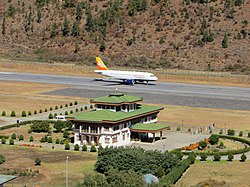
Paro International Airport (Dzongkha: སྤ་རོ་གནམ་ཐང༌།, romanized: paro gnam thang) (IATA: PBH, ICAO: VQPR) is the sole international airport of the four airports in Bhutan. It is 6 kilometres (3.7 mi; 3.2 nmi) from Paro in a deep valley on the bank of the river Paro Chhu. With surrounding peaks as high as 5,500 metres (18,000 ft), it is considered one of the world's most challenging airports,[2] and only a very small number of pilots are certified to land at the airport.[citation needed]
Flights to and from Paro are allowed under visual meteorological conditions only and are restricted to daylight hours from sunrise to sunset.[3][4] Paro airport was the only airport in Bhutan until 2011.[5] The airport is accessible by road, 6 km (3.7 mi; 3.2 nmi) from Paro city, and 54 km (34 mi; 29 nmi) from Thimphu by Paro-Thimphu road.
- ^ a b "About Us". Paro Airport. Retrieved 3 January 2022.
- ^ Cruz, Magaly; Wilson, James; Nelson, Buzz (July 2003). "737-700 Technical Demonstration Flights in Bhutan" (PDF). Aero Magazine (3): 1, 2. Retrieved 12 February 2011.
- ^ "Paro Bhutan". Air Transport Intelligence. Reed Business Information. 2011. Archived from the original on 7 August 2011. Retrieved 12 February 2011.
- ^ Lee, Natalie Joy (2 August 2019). "7 Facts You Never Knew About Flying Into Bhutan". Druk Asia. Retrieved 3 January 2022.
- ^ "History". Archived from the original on 23 November 2016.
