Back بوكالبا Arabic بوكالبا ARZ Pukallpa Aymara Pucallpa Catalan Pucallpa (kapital sa rehiyon sa Peru) CEB Pucallpa Czech Pucallpa Danish Pucallpa German Pucallpa Esperanto Pucallpa Spanish
This article has multiple issues. Please help improve it or discuss these issues on the talk page. (Learn how and when to remove these template messages)
|
Pucallpa
May Ushin Pukallpa | |
|---|---|
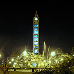
Main Square, Saint Francis port, Tacna avenue, Natural park of Pucallpa and San Martín Square. | |
| Nickname: La tierra colorada (The Crimson Land) | |
| Coordinates: 8°23′S 74°31′W / 8.383°S 74.517°W | |
| Country | Peru |
| Region | Ucayali |
| Province | Coronel Portillo |
| Settled | 1840s |
| Government | |
| • Mayor | Segundo Pérez Collazos (2019–2022) |
| Elevation | 154 m (505 ft) |
| Population (2017) | |
| • Total | 326,040 |
| • Estimate (2015)[1] | 211,651 |
| Time zone | UTC-5 (PET) |
| • Summer (DST) | UTC-5 (PET) |
| Website | mpcp |
Pucallpa (/pʊˈkælpə/, Quechua: puka allpa, lit. 'red dirt'; Shipibo: May Ushin) is a city in eastern Peru located on the banks of the Ucayali River, a major tributary of the Amazon River. It is the capital of the Ucayali region, the Coronel Portillo Province and the Calleria District.[2] This city is categorized as the only metropolis in Ucayali, being the largest populated center of the region. According to the Instituto Nacional de Estadística e Informática, it is the tenth most populated city in Peru and second largest in the Peruvian Amazon after Iquitos. In 2013 it housed a population of 211,611 inhabitants.
Although originally located in the district of Callería, in the 1980s it formed a conurbation with the towns of Puerto Callao (district of Yarinacocha) and San Fernando (district of Manantay, created in 2000).
Most of the transport to Pucallpa is done through the Ucayali River, located in the central east of Peru and which contains the second most important river port in the Amazon (behind Iquitos). The Federico Basadrees highway is the main center of land transportation and connects the northwest of the city with the Captain Rolden International Airport (Aeropuerto Internacional Capitán FAP David Abensur Rengifo), where flights are made to Brazil.[citation needed]
The economy of Pucallpa is based on trade, the timber industry and tourism. Among the main attractions of the city include ecological tourism, such as the Parque Natural, or cultural tourism, in the case of shamanism. Its main economic activities are fishing, agriculture, livestock and timber extraction. In addition, a small oil refinery near the Pachitea River and a gas refinery in the Curimaná District supply fuel to the city and the center of the country.[3]
The first human inhabitants of the region were the Pano, who inhabited the entire length of the Ucayali River and its tributaries three millennia before being colonized.
- ^ Perú: Población estimada al 30 de junio y tasa de crecimiento de las ciudades capitales, por departamento, 2011 y 2015. Perú: Estimaciones y proyecciones de población total por sexo de las principales ciudades, 2012–2015 (Report). Instituto Nacional de Estadística e Informática. March 2012. Retrieved 3 June 2015.
- ^ "Pucallpa | Peru | Britannica". www.britannica.com. Retrieved 24 March 2023.
- ^ "Pucallpa | Low Amazon | Lake Yarinacocha, Ucayali River | Shipibo | Sierra del Divisor, Alto Purus". Northern Peru & Amazonia Tours | Kuelap & Gocta | Amazon River Cruises & Lodges. Retrieved 24 March 2023.


