Back Rayne Township, Pennsylvania Welsh Municipio de Rayne Spanish Rayne Township French Рейн Тауншип (округ Індіана, Пенсільванія) Ukrainian Xã Rayne, Quận Indiana, Pennsylvania Vietnamese
Rayne Township, Pennsylvania | |
|---|---|
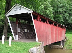
 Kintersburg Covered Bridge (1877) National Register of Historic Places | |
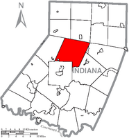
 Map of Indiana County, Pennsylvania Highlighting Rayne Township | |
 Map of Pennsylvania highlighting Indiana County | |
| Country | United States |
| State | Pennsylvania |
| County | Indiana |
| Area | |
| • Total | 47.25 sq mi (122.39 km2) |
| • Land | 47.13 sq mi (122.05 km2) |
| • Water | 0.13 sq mi (0.33 km2) |
| Population | |
| • Total | 2,809 |
| • Estimate (2021)[2] | 2,796 |
| • Density | 60.50/sq mi (23.36/km2) |
| Time zone | UTC-5 (Eastern (EST)) |
| • Summer (DST) | UTC-4 (EDT) |
| FIPS code | 42-063-63584 |
Rayne Township is a township that is located in Indiana County, Pennsylvania, United States.
The population was 2,809 at the time of the 2020 census,[2] This township surrounds but does not include the borough of Ernest.
- ^ "2016 U.S. Gazetteer Files". United States Census Bureau. Retrieved August 14, 2017.
- ^ a b c Bureau, US Census. "City and Town Population Totals: 2020-2021". Census.gov. US Census Bureau. Retrieved July 7, 2022.