Back Saint-Damase (munisipyo sa Bas-Saint-Laurent) CEB سن-داماز (با-سن-لوران) Persian Saint-Damase (La Matapédia) French Saint-Damase (kommun i Kanada, Bas-Saint-Laurent) Swedish سینٹ-دامسے، بس-سینٹ-لارنٹ، کیوبک Urdu
You can help expand this article with text translated from the corresponding article in French. (November 2012) Click [show] for important translation instructions.
|
Saint-Damase | |
|---|---|
 | |
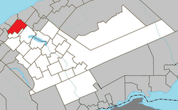
 Location within La Matapédia RCM. | |
| Coordinates: 48°40′N 67°50′W / 48.667°N 67.833°W[1] | |
| Country | |
| Province | |
| Region | Bas-Saint-Laurent |
| RCM | La Matapédia |
| Settled | 1868 |
| Constituted | December 31, 1885 |
| Government | |
| • Mayor | Jean-Marc Dumont |
| • Federal riding | Haute-Gaspésie—La Mitis—Matane—Matapédia |
| • Prov. riding | Matane-Matapédia |
| Area | |
| • Total | 118.20 km2 (45.64 sq mi) |
| • Land | 116.42 km2 (44.95 sq mi) |
| Population | |
| • Total | 382 |
| • Density | 3.3/km2 (9/sq mi) |
| • Pop 2016-2021 | |
| • Dwellings | 178 |
| Time zone | UTC−5 (EST) |
| • Summer (DST) | UTC−4 (EDT) |
| Postal code(s) | |
| Area code(s) | 418 and 581 |
| Highways | |
| Website | saint-damase |
Saint-Damase is a parish municipality in Quebec, Canada.
- ^ Cite error: The named reference
toponymiewas invoked but never defined (see the help page). - ^ a b "Saint-Damase". Répertoire des municipalités (in French). Ministère des Affaires municipales, des Régions et de l'Occupation du territoire. Retrieved 2012-01-26.
- ^ "Census Profile, 2021 Census - Saint-Damase, Census subdivision, Quebec". 26 October 2022.
- ^ "Census Profile, 2021 Census - Saint-Damase, Census subdivision, Quebec". 26 October 2022.
