Back Santa Rosa-eiland Afrikaans Santa Rosa Island (pulo sa Tinipong Bansa, Florida) CEB Isla Santa Rosa (Florida) Spanish Santa Rosa Island (Floride) French 聖羅莎島 (佛羅里達州) Chinese
This article is missing information about physical features. (August 2017) |
Santa Rosa Island
The Island of Santa Rosa | |
|---|---|
| Nickname: SRI | |
| Country | United States |
| State | Florida |
| County | Escambia, Santa Rosa, Okaloosa County, Florida |
| Time zone | UTC-6 (CST) |
| Area code | 850 |
 | |


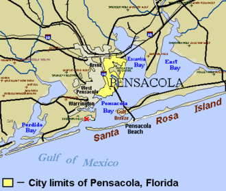
30°22′57″N 86°51′23″W / 30.38250°N 86.85639°WSanta Rosa Island is a 40-mile (64 km) barrier island located in the U.S. state of Florida, thirty miles (50 km) east of the Alabama state border. The communities of Pensacola Beach, Navarre Beach, and Okaloosa Island are located on the island. On the northern side of the island, are Pensacola Bay on the west (see map) and Choctawhatchee Bay on the east, joined through Santa Rosa Sound.
Santa Rosa Island has weathered numerous hurricanes and other tropical cyclones, including the hurricane of September 1559, Hurricane Erin and Hurricane Opal (both in 1995), Hurricane Ivan (2004), Hurricane Dennis (2005), Tropical Storm Claudette (2009), and the remnants of Hurricane Ida (2009).
Parts of the island are protected from development within the Gulf Islands National Seashore.