Back ساتسوماسينداي (كاغوشيما) Arabic ساتسوماسندای، کاقوشیما AZB Сацумасендай CE Satsumasendai CEB Satsumasendai German Satsumasendai Spanish ساتسوماسندای، کاگوشیما Persian Satsuma-Sendai Finnish Satsumasendai French Satsumasendai Galician
Satsumasendai
薩摩川内市 | |
|---|---|
 | |
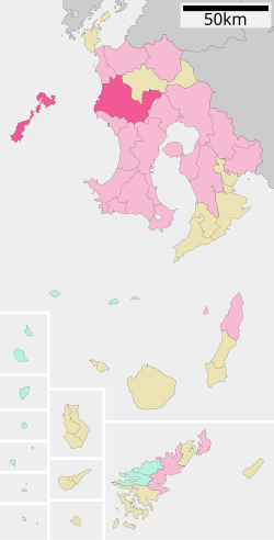
 Location of Satsumasendai in Kagoshima Prefecture | |
| Coordinates: 31°49′N 130°18′E / 31.817°N 130.300°E | |
| Country | Japan |
| Region | Kyushu |
| Prefecture | Kagoshima Prefecture |
| Government | |
| • Mayor | Hideo Iwakiri |
| Area | |
| • Total | 683.50 km2 (263.90 sq mi) |
| Population (May 1, 2017) | |
| • Total | 96,411 |
| • Density | 140/km2 (370/sq mi) |
| Time zone | UTC+09:00 (JST) |
| City hall address | 3-22, Kandachō, Satsumasendai-shi, Kagoshima-ken 895-8650 |
| Climate | Cfa |
| Website | www |
| Symbols | |
| Bird | Japanese white-eye |
| Fish | Stream: Ayu Oceanic: Slender sprat |
| Flower | Lilium speciosum |
| Tree | Round leaf holly (Ilex rotunda) |

Satsumasendai (薩摩川内市, Satsumasendai-shi) is a city located in Kagoshima Prefecture, Japan.
The modern city of Satsumasendai was established on October 12, 2004, from the merger of the city of Sendai, the towns of Hiwaki, Iriki, Kedōin and Tōgō, and the Koshikijima Islands (which consisted of the villages of Kamikoshiki, Kashima, Sato and Shimokoshiki, all from Satsuma District).
As of May 2017, the city has an estimated population of 96,411 and a population density of 140 persons per km2.[1] The total area is 683.50 km2.
The city has regular Shinkansen services to Kagoshima City and Yatsushiro.
The city is also home to Kagoshima Immaculate Heart University, founded in 1994, which has a small population of foreign students.
A major employer is the Sendai nuclear power station.
- ^ "Official website of Satsumasendai City" (in Japanese). Japan: Satsumasendai City. Retrieved 7 May 2017.


