| Sawtooth Range | |
|---|---|
 | |
| Highest point | |
| Peak | Thompson Peak |
| Elevation | 10,756 ft (3,278 m) NAVD 88[1] |
| Coordinates | 44°08′30″N 115°00′36″W / 44.141533°N 115.009969°W |
| Dimensions | |
| Length | 43 mi (69 km) N/S |
| Width | 25 mi (40 km) E/W |
| Area | 678 sq mi (1,760 km2) |
| Geography | |
| Country | United States |
| State | Idaho |
| Counties | Custer, Boise, Blaine and Elmore |
| Range coordinates | 43°57′12″N 114°59′26″W / 43.95333°N 114.99056°W[2] |
| Parent range | Rocky Mountains |
| Borders on | Sawtooth Valley |
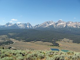
The Sawtooth Range is a mountain range of the Rocky Mountains in central Idaho, United States, reaching a maximum elevation of 10,751 feet (3,277 m) at the summit of Thompson Peak. It encompasses an area of 678 square miles (1,756 km2) spanning parts of Custer, Boise, Blaine, and Elmore counties, and is bordered to the east by the Sawtooth Valley. Much of the mountain range is within the Sawtooth Wilderness, part of the Sawtooth National Recreation Area and Sawtooth National Forest.[3]
The mountains were named for their jagged peaks.[4]
- ^ "Goat". NGS Data Sheet. National Geodetic Survey, National Oceanic and Atmospheric Administration, United States Department of Commerce. Retrieved 2022-10-08.
- ^ "Sawtooth Range". Geographic Names Information System. United States Geological Survey, United States Department of the Interior. Retrieved June 23, 2013.
- ^ Sawtooth National Forest (Map) (2012 ed.). 1:126,720. Sawtooth National Forest, U.S. Forest Service.
- ^ Rees, John E. (1918). Idaho Chronology, Nomenclature, Bibliography. W.B. Conkey Company. p. 109.

