Back Stowe Township, Pennsylvania Welsh Municipio de Stowe Spanish استو تاونشیپ، شهرستان الگینی، پنسیلوانیا Persian Stowe Township French Stowe (Pennsylvania) Italian Stowe Township Dutch Stowe Township Portuguese Стоу Тауншип (округ Аллегені, Пенсільванія) Ukrainian Stowe Township Uzbek Xã Stowe, Quận Allegheny, Pennsylvania Vietnamese
Stowe Township | |
|---|---|
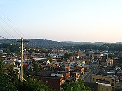
 A small part of the West Park neighborhood in Stowe Township. Sto-Rox High School is visible. | |
 Location in Allegheny County and state of Pennsylvania | |
| Coordinates: 40°28′47″N 80°4′26″W / 40.47972°N 80.07389°W | |
| Country | United States |
| State | Pennsylvania |
| County | Allegheny |
| Area | |
| • Total | 2.30 sq mi (5.95 km2) |
| • Land | 1.98 sq mi (5.13 km2) |
| • Water | 0.32 sq mi (0.81 km2) |
| Population (2010) | |
| • Total | 6,362 |
| • Estimate (2018)[2] | 6,166 |
| • Density | 3,131.18/sq mi (1,208.75/km2) |
| Time zone | UTC-5 (Eastern (EST)) |
| • Summer (DST) | UTC-4 (EDT) |
| ZIP codes | 15136 |
| Area code | 412 |
| FIPS code | 42-003-74648 |
Stowe Township is a township in Allegheny County, Pennsylvania, United States. The population was 6,362 at the 2010 census.[3]
It is located in the Sto-Rox School District, which serves both Stowe Township and the neighboring borough of McKees Rocks. All locations in Stowe Township have McKees Rocks addresses.
Stowe Township has partnered with the Allegheny Together organization to revitalize its main business district on Broadway Avenue.
The area is served by Port Authority bus routes 21, 22, and 24.
- ^ "2016 U.S. Gazetteer Files". United States Census Bureau. Retrieved August 13, 2017.
- ^ Bureau, U. S. Census. "U.S. Census website". United States Census Bureau. US Census Bureau. Retrieved December 1, 2019.
- ^ "Race, Hispanic or Latino, Age, and Housing Occupancy: 2010 Census Redistricting Data (Public Law 94-171) Summary File (QT-PL), Stowe township, Allegheny County, Pennsylvania". United States Census Bureau. Retrieved September 30, 2011.
