Back مدينة سوريجاو Arabic Syudad nin Surigao BCL Ciudad de Surigao CBK-ZAM Dakbayan sa Surigao CEB Surigao City German Surigao Esperanto Surigao Spanish Surigao French Kota Surigao ID Surigao ILO
Surigao City | |
|---|---|
| City of Surigao | |
 Surigao City Hall | |
| Nickname: City of Island Adventures | |
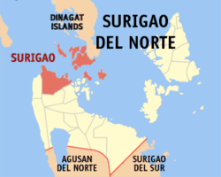
 Map of Surigao del Norte with Surigao City highlighted | |
Location within the Philippines | |
| Coordinates: 9°47′23″N 125°29′45″E / 9.7897°N 125.4958°E | |
| Country | Philippines |
| Region | Caraga |
| Province | Surigao del Norte |
| District | 2nd district |
| Founded | June 29, 1655 |
| Cityhood | August 31, 1970 |
| Barangays | 54 (see Barangays) |
| Government | |
| • Type | Sangguniang Panlungsod |
| • Mayor | Pablo Yves L. Dumlao II |
| • Vice Mayor | Alfonso S. Casurra |
| • Representative | Robert Ace S. Barbers |
| • City Council | Members |
| • Electorate | 108,959 voters (2022) |
| Area | |
| • Total | 245.30 km2 (94.71 sq mi) |
| Elevation | 43 m (141 ft) |
| Highest elevation | 984 m (3,228 ft) |
| Lowest elevation | 0 m (0 ft) |
| Population (2020 census)[3] | |
| • Total | 171,107 |
| • Density | 700/km2 (1,800/sq mi) |
| • Households | 41,816 |
| Economy | |
| • Income class | 1st city income class |
| • Poverty incidence | 24.91 |
| • Revenue | ₱ 983.8 million (2020) |
| • Assets | ₱ 2,839 million (2020) |
| • Expenditure | ₱ 982.2 million (2020) |
| • Liabilities | ₱ 302.4 million (2020) |
| Service provider | |
| • Electricity | Surigao del Norte Electric Cooperative (SURNECO) |
| Time zone | UTC+08:00 (PST) |
| ZIP code | 8400 |
| PSGC | |
| IDD : area code | +63 (0)86 |
| Native languages | Surigaonon Agusan Cebuano Tagalog |
| Website | www |
Surigao City, officially the City of Surigao (Surigaonon: Siyudad nan Surigao; Cebuano: Dakbayan sa Surigao; Filipino: Lungsod ng Surigao), is a 1st class component city and capital of the province of Surigao del Norte, Caraga Region (Administrative Region XIII), on the north-eastern island of Mindanao, Philippines.
The city is located at the north-easternmost tip of Mindanao with a total land area of 245.34 km2 which is roughly 1.4% of Caraga region.
The absence of a fort in Surigao belies its significance and sphere of influence during the Spanish period. It was the capital of the expansive province of the same name from 1750 until its dissolution in 1911, covering a third of Mindanao Island's total land area. It is one of the oldest port towns in Mindanao, founded by Spanish colonizers in 1655. It has abundant mineral reserves including gold, iron, manganese, silica, cobalt, copper, chromite and among the world's largest nickel deposits in Nonoc Island. The city has been dubbed the mining capital since 1969 of the then Northern Mindanao region and still today as an economic driver of Caraga region.
Surigao City serves as a jump off point to visitors of nearby Siargao, Dinagat and Bucas Grande islands. It is Mindanao's closest landmass to the Visayas region, separating the two island groups by eleven nautical miles across Surigao Strait. Surigao is the center of politics, commerce, banking, industry and education of Surigao del Norte and Dinagat Islands as well as parts of neighboring provinces of Surigao del Sur, Agusan del Norte and Southern Leyte.
- ^ City of Surigao | (DILG)
- ^ "2015 Census of Population, Report No. 3 – Population, Land Area, and Population Density" (PDF). Philippine Statistics Authority. Quezon City, Philippines. August 2016. ISSN 0117-1453. Archived (PDF) from the original on May 25, 2021. Retrieved July 16, 2021.
- ^ Census of Population (2020). "Caraga". Total Population by Province, City, Municipality and Barangay. Philippine Statistics Authority. Retrieved 8 July 2021.
- ^ "PSA Releases the 2021 City and Municipal Level Poverty Estimates". Philippine Statistics Authority. 2 April 2024. Retrieved 28 April 2024.


