Back ولاية تمنراست Arabic Provincia de Tamanrasset AST تمنراست اوستانی AZB Таманрасет (правінцыя) Byelorussian Таманрасэт (вілает) BE-X-OLD Таманрасет (област) Bulgarian Таманрассет (вилайет) CE Wilaya de Tamanrasset CEB Provinz Tamanrasset German Επαρχία Ταμανρασσέτ Greek
Tamanrasset Province
ولاية تمنراست | |
|---|---|
| Province of Tamanrasset | |
 | |
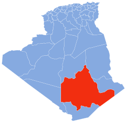
 Map of Algeria highlighting Tamanrasset | |
| Coordinates: 22°47′N 05°31′E / 22.783°N 5.517°E | |
| Country | |
| Capital | Tamanrasset |
| Government | |
| • Governor | Shater Abdel Karim |
| Area | |
| • Total | 557,906 km2 (215,409 sq mi) |
| • Rank | 1st |
| Elevation | 1,400 m (4,600 ft) |
| Highest elevation | 3,303 m (10,837 ft) |
| Population (2008)[2] | |
| • Total | 115,043 (within current boundaries) |
| • Rank | 50th |
| • Density | 0.206/km2 (0.53/sq mi) |
| Time zone | UTC+01 (CET) |
| Area Code | +213 (0) 29 |
| ISO 3166 code | DZ-11 |
| Districts | 3 |
| Municipalities | 5 |
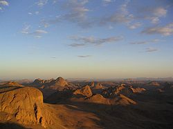
Tamanrasset or Tamanghasset (Arabic: ولاية تمنراست Wilāya Tamanrāssat, Berber languages) is the largest province (wilaya) in Algeria. It was named after its province seat, Tamanrasset. The province has two national parks, more than any other in Algeria. They are Tassili n'Ajjer National Park and Ahaggar National Park. The province is the largest in Algeria as it is 557,906 km2 large.
- ^ Ighil, Ravah (1 Feb 2017). "L'Ecole de police livrée avant juin 2017". El Watan (in French). Retrieved 21 Jul 2022.
- ^ Office National des Statistiques, Recensement General de la Population et de l’Habitat 2008 Archived 2008-07-24 at the Wayback Machine Preliminary results of the 2008 population census. Accessed on 2008-07-02.