Back تاماقوا (بنسيلفانيا) Arabic تاماکوا، پنسیلوانیا AZB Tamaqua Catalan Тамаква (Пенсильвани) CE Tamaqua CEB Tamaqua, Pennsylvania Welsh Tamaqua DAG Tamaqua German Tamaqua Spanish Tamaqua (Pennsylvania) Basque
Tamaqua
tëmakwe | |
|---|---|
Borough | |
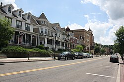
 West Broad Street in Tamaqua in July 2013 | |
| Etymology: Corruption of Native American word "Tankamochkhanna" meaning "Little Beaver Stream"[1] | |
 Location of Tamaqua in Schuylkill County, Pennsylvania (left) and of Schuylkill County in Pennsylvania (right) | |
Location of Tamaqua in Pennsylvania | |
| Coordinates: 40°47′55″N 75°57′59″W / 40.79861°N 75.96639°W | |
| Country | |
| State | |
| County | Schuylkill |
| Incorporated | 1832 |
| Government | |
| • Mayor | Nathan Gerace (R)[2] |
| Area | |
| • Total | 9.72 sq mi (25.17 km2) |
| • Land | 9.56 sq mi (24.77 km2) |
| • Water | 0.16 sq mi (0.40 km2) |
| Elevation | 870 ft (270 m) |
| Population | |
| • Total | 6,934 |
| • Estimate (2021)[4] | 6,932 |
| • Density | 696.93/sq mi (269.07/km2) |
| Demonym | Tamaquan |
| Time zone | UTC-5 (EST) |
| • Summer (DST) | UTC-4 (EDT) |
| ZIP Code | 18252 |
| Area code(s) | 570 and 272 |
| FIPS code | 42-76032 |
| School district | Tamaqua Area |

Tamaqua (/təˈmɑːkwə/, Delaware: tëmakwe)[5] is a borough in eastern Schuylkill County in the Coal Region of Pennsylvania, United States. It had a population of 6,934 as of the 2020 U.S. census.[4]
Tamaqua was established from territory from West Penn and Schuylkill Townships. The borough is part of the micropolitan statistical area of Pottsville.
Tamaqua is located 37.8 miles (60.8 km) northwest of Allentown, 87 miles (140 km) northwest of Philadelphia, and 125.5 miles (202.0 km) west of New York City.
- ^ "Schuylkill County History: Indian Names". Archived from the original on May 4, 2010. Retrieved April 5, 2011.
- ^ "19-year-old Now Mayor-Elect of Tamaqua". November 9, 2017.
- ^ "2019 U.S. Gazetteer Files". United States Census Bureau. Retrieved July 28, 2020.
- ^ a b c "City and Town Population Totals: 2020—2021". Census.gov. US Census Bureau. Retrieved August 1, 2022.
- ^ Online Lenape Talking Dictionary, "https://www.talk-lenape.org/detail?id=10044", Link

