| Tatura Victoria | |||||||||
|---|---|---|---|---|---|---|---|---|---|
 Main street | |||||||||
| Coordinates | 36°26′0″S 145°14′0″E / 36.43333°S 145.23333°E | ||||||||
| Population | 4,955 (2021 census)[1] | ||||||||
| Postcode(s) | 3616 | ||||||||
| Elevation | 114 m (374 ft) | ||||||||
| Location |
| ||||||||
| LGA(s) | City of Greater Shepparton | ||||||||
| State electorate(s) | Shepparton | ||||||||
| Federal division(s) | Nicholls | ||||||||
| |||||||||
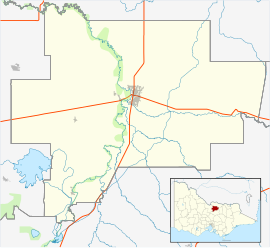
Tatura is a town in the Goulburn Valley region of Victoria, Australia, and is situated within the City of Greater Shepparton local government area, 167 kilometres (104 mi) north of the state capital (Melbourne) and 18 kilometres (11 mi) west of the regional centre of Shepparton. At the 2021 census, Tatura had a population of 4,955.[1]
During World War II, several internment camps were set up around Tatura by the Australian government. Four of these were for "enemy alien" civilians, and three were for prisoners of war. Between 1940 and 1947, there were 10,000 to 13,000 people in the internment camps at different times.
With a large corporate and manufacturing presence within the town, Tatura is a major employer within the Goulburn Valley. Attractions include the Cussen Park wetlands, the Wartime Camps, and Irrigation Museum. The name of the town is an Aboriginal word meaning "small lagoon."
- ^ a b Australian Bureau of Statistics (27 June 2017). "Tatura (State Suburb)". 2016 Census QuickStats. Retrieved 20 April 2018.

